Workable SE swell Tuesday, building E/NE groundswell late week

Sydney, Hunter and Illawarra Surf Forecast by Guy Dixon (issued Monday 18th January)
Best Days: Tuesday morning, Wednesday morning and Thursday morning.
Recap:
A good looking 3-4ft southerly groundswell was impacted by gusty and persistent southerlies for the better part of Saturday, however the situation improved on Sunday morning with a few hours of westerly winds blowing before dawn. By that stage, the surf had eased to the 2-3ft range, but there were some clean, workable peaks on offer.
Today, we've seen workable peaks in the 2ft range up and down the coast, only slightly impacted by a light seabreeze this afternoon.
This week (Tuesday 19th - Friday 22nd):
Late last week, we mentioned that models severely downgraded and delayed a low pressure system which was due to form over the Tasman on Friday/Saturday. However, over the weekend, models gave this system a little bit more intensity and we are due to see the impacts of the southeasterly fetches from its southern quadrants on Tuesday.
Although the size and alignment of this fetch hasn’t been ideal, south facing beaches should still receive 2-3ft options on Tuesday morning, larger across the Hunter.
Residual background energy should continue to fill in across the open beaches with the surf holding in the 1-2ft range.
Conditions look to be clean for the morning session with light northwesterlies blowing across the Sydney and Illawarra coasts, more north/northwesterly for the Hunter. A northerly airflow should increase and tend more northeasterly throughout the day, having an impact on the quality.
The aforementioned northerly component airflow is actually part of a broader fetch which looks to develop on Tuesday along the coast of NSW, increasing into the afternoon and evening.
By Wednesday morning, open beaches should be seeing the effects of this windswell, with peaky options in the 2ft range.
Breezes should show a similar pattern for Wednesday, light northwesterly early, increasing from the northeast later.
A weak southerly change looks to disrupt this northerly fetch overnight from Wednesday into Thursday morning, however soon redeveloping and persisting throughout Friday.
If this system wasn’t to be disrupted by a weak southerly, the duration would’ve led to a more notable increase in northeasterly windswell, however Thursday should only see peaky options in the 2ft+ range, holding at a similar size on Friday.
Light variable winds should last until much later on Thursday morning, before giving way to a northeasterly seabreeze, although much lighter than the previous days.
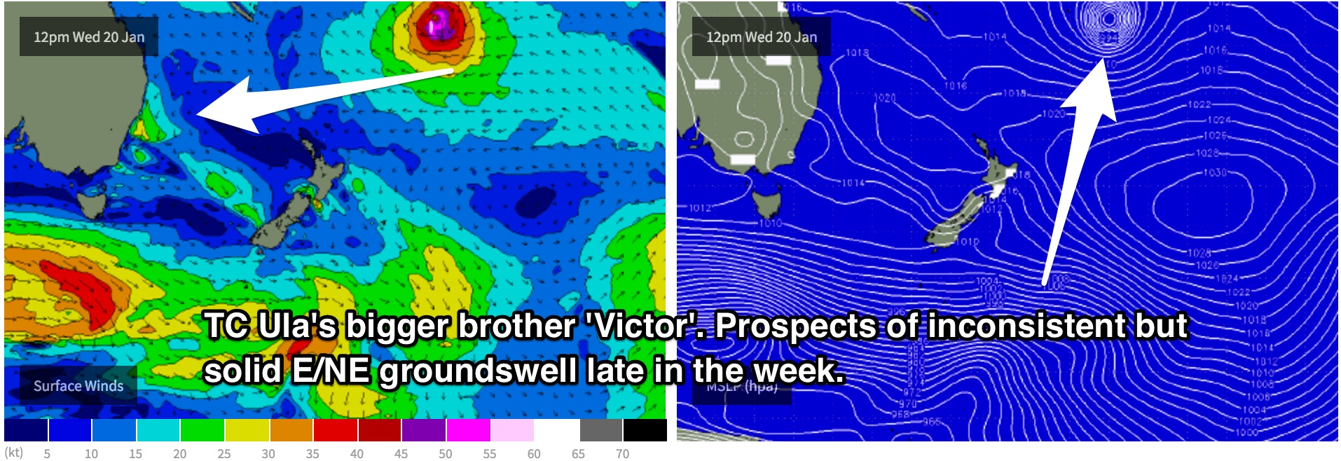
The end of the week brings much more promising prospects for surf, with long range groundswell filling in from Tropical Cyclone Victor, a system residing in the tropical South Pacific near Fiji.
East/northeasterly groundswell looks to provide very inconsistent sets building to the 3ft range across the open beaches by Friday afternoon, larger into the weekend.
At this stage, Victor is forecast to follow a slow track southward leading into the weekend, allowing consistency to improve and size to increase slightly.
Just for something different, northerly breezes are on the cards. The morning session should offer a window of workable waves, but not like the mornings prior. Winds may tend north/northwesterly, but ultimately giving way to a seabreeze easier/earlier.
This weekend (Saturday 23rd - Sunday 24th):
Saturday has the potential to see inconsistent 3ft+ sets, building to the 3-4ft range on Sunday. Again, it’s worth highlighting that consistency will be an issue due to the very long range of this system, so patience will be essential.
Subtle pulses of background southerly energy are also due fill in across the south swell magnets from occasional and poorly aligned frontal activity, although only look to provide options in the 1-2ft range.
A southerly change (the true southerly change) looks to move through on Saturday, although the opinions between models range somewhere from midnight Friday into Saturday to late Saturday morning. More detail will be available in coming updates, but in either scenario, open beaches are where you want to be.
Sunday is looking at lighter winds tending more southeasterly, but again, most of the action will be breaking across the open beaches.
As mentioned earlier, the solid east/northeasterly groundswell generated by TC Victor is likely to be at its best late on the weekend, leading into the early stages of the working week.
Next week (Monday 25th onward):
Victor’s east/northeasterly groundswell looks to be the best and most dominant swell into the early stages of next week, so open beaches will be the place to keep an eye on for occasional sets in the 3-4ft range.
Comments
SE swell kicked in nicely around 7am this morning, good 3ft sets across most open beaches. Here's a good 3ft set moving into Manly, albeit bumpy..