Active southern swell window in the coming days

Sydney, Hunter and Illawarra Surf Forecast by Guy Dixon (issued Wednesday 13th January)
Best Days: Thursday, Monday morning and Tuesday morning.
Recap:
Conditions over the past couple of days have remained pretty small and weak along the Sydney, Hunter and Illawarra coasts, with options really only in the 1-2ft range, nothing like what we saw over the weekend. On the plus side, winds have remained generally light/moderate so even under an afternoon seabreeze, the surf has been workable for those keen to cool off.
This week (Thursday 14th - Friday 15th):
Later this afternoon, we are due to see the first signs of a very inconsistent southerly groundswell generated by a small but intense low pressure system which sat off the ice shelf of Antarctica, earlier in the week. The 50kt winds which blew for 24 hours are expected to provide inconsistent sets in the 2-3ft range across the south swell magnets on Thursday, peaking through the afternoon to 3-4ft.
Meanwhile, Tropical Cyclone Ula is moving along her southeasterly path towards cooler waters, whilst remaining a particularly intense system. Granted, this storm is moving further into our swell window, however its track is not ideal.
We would like to see this system move in the same direction as the strongest swell generating winds, but instead it’s moving in a perpendicular motion, across our swell window. Nevertheless, we should still see inconsistent effects off this system, with open beaches picking up occasional sets in the 2-3ft range.
Breezes are looking good for a wave in the morning, prevailing from the northwest early preceding a possible northeasterly shift in the afternoon.
A southerly buster is still on track to move up the coast on Thursday afternoon/evening following a particularly hot day. Gusts of around 50-60km/h are due with the change, but look to become more intense throughout the overnight hours.
As a result, south facing beaches should see a strong kick in short range southerly windswell to the 4-5ft range with the odd bigger set throughout Friday, larger across the Hunter, although displaying little to no quality. Fresh/strong winds persisting throughout the day are likely to kill any chances of a decent wave across south facing beaches, with the only options worth considering being limited to protected southern corners of the open beaches.
This weekend (Saturday 16th - Sunday 17th):
Southerly swell should fade throughout Saturday and Sunday, being slowed only by persisting southerly fetches and weaker pulses of southerly groundswell. Saturday should fade from the 3-5ft range, largest at exposed south facing beaches, while Sunday is looking at easing from the 3ft+ range.
A persistent moderate/fresh south/southeasterly breeze looks to dominate for the majority of Saturday limiting options to the open beaches once again.
Sunday is looking at a slightly better wind outlook, with moderate south/southwesterly breezes continuing (south-west across the Northern Beaches early).
Next week (Monday 18th onward):
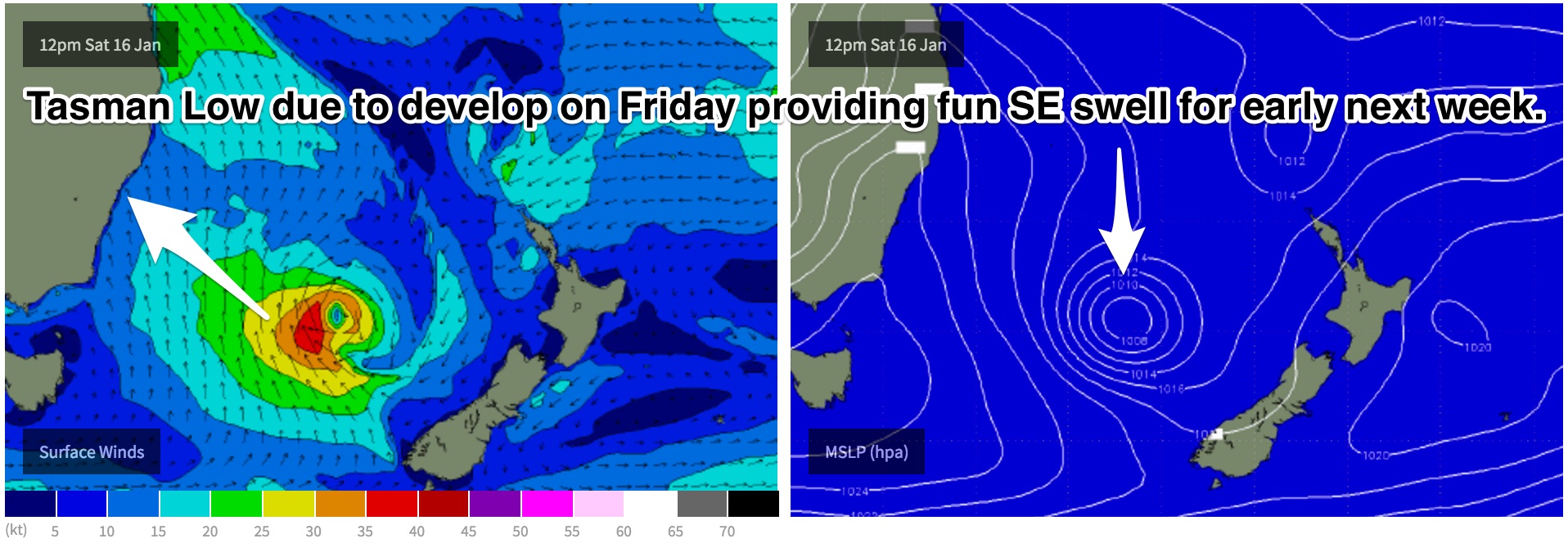 The next most notable system is looking to develop in the form of a Tasman Low sometime during Friday. Model consensus has been growing regarding the timing and positioning of this system and now shows good confidence.
Saturday will be the day of most significant swell generation, with the effects of this system looking to fill in across the NSW coast on Monday morning, with some pretty good looking options on offer.
At this stage, the morning should see options in the 3-4ft+ range, larger across the Hunter, under a light offshore airflow. Breezes look to remain light/variable until at late morning before giving way to a seabreeze when the quality of the surf will inevitably diminish.
This is definitely a day to keep an eye on as conditions are looking to come together nicely, particularly as the weekend looks to be plagued by gusty southerlies.
The best part of this system is its duration. Models suggest that this low should hang around in the Tasman for a few days, with southeasterly fetches, although slightly weaker still working on an active sea state.
Tuesday should see options holding in the 3ft range, with light northwesterly breezes on the forecast for the morning, soon tending gusty northeasterly.
Trailing southeasterly fetches should maintain southeasterly energy later in the week, slowly fading.
More detail in Friday's notes.
Comments
As expected it's very inconsistent this morning but the Bondi surfcam is picking up occasional 3ft sets. I can imagine it'd be a pretty frustrating day of waves in Southern NSW though; there's nothing between the sets at all.
Nice lines...
Solid! That's gotta be 3ft+.
3' plus up on the central coast ben, plus what I would assume a 2' or so from Ula coming through, definitely two distinct swells in the water.
Offshore, hot, waves, you'd think a man could find somewhere that was both working and not over-run with crowds, especially on the northern extremes of the central coast, but the banks are not in a good state.
Found what looked like a great spot but it just went weird, not from lack of swell though. God it's hot out there.
Unreal. Waiting on the south swell to hit up here on the North Coast!
Inco but waves here northern beaches this morning. Interesting none of Tuesday SE swell is showing up on models. Just NE facing beaches.