Leftovers for breakfast this weekend

Sydney, Hunter and Illawarra Surf Forecast by Guy Dixon (issued Friday 8th January)
Best Days: Saturday morning, then south facing beaches for the afternoon session. Sunday morning for left overs.
Recap:
Thursday morning started off nicely, with a southeasterly swell providing 5-6ft sets across the Sydney and Illawarra stretch, slightly larger across the Hunter. Southwesterly breezes helped clean things up, but as the afternoon progressed, the better, smaller options were found at the protected south ends of the open beaches.
The real pick of the bunch came this morning, and what a morning it was! It's been absolutely pumping across the coast today, with offshore breezes grooming the lineup perfectly. Open beaches woke to velvetty 4-5ft+ sets, with exposed south facing beaches offering solid 6ft+ bombs.
This weekend (Saturday 9th - Sunday 10th):
Residual energy from today's southeasterly swell should still be in the mix for the early session on Saturday, with around 3-4ft breaking across south facing beaches, fading fairly steadily.
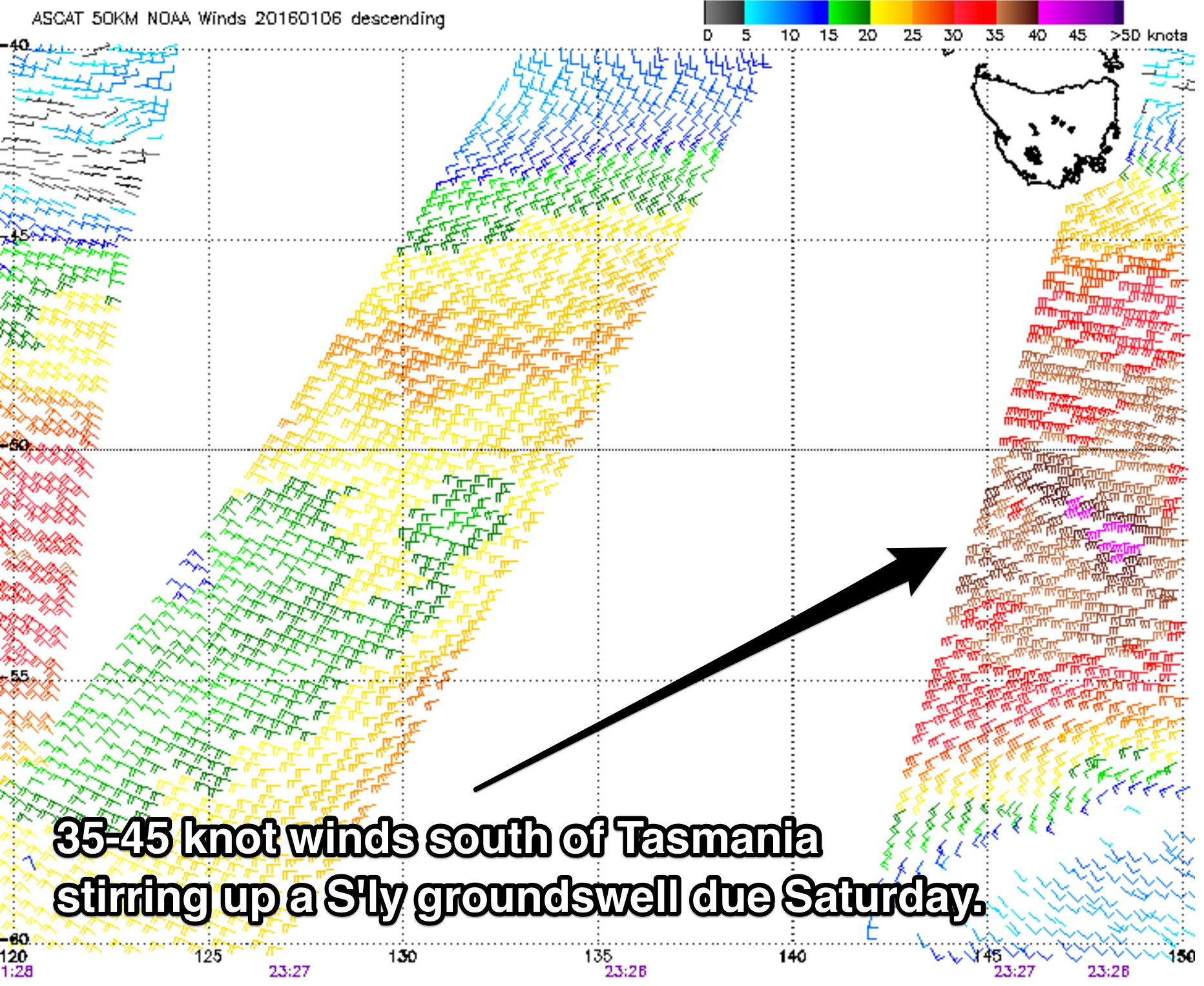 The southern swell window then becomes the main focus as we see the effects of a frontal progression which moved over the Southern Ocean over the past few days.
A broad fetch of 35-45kt west/southwesterly winds in the wake of a frontal progression moved to the south and east of Tasmania overnight, the effects of which are due to move up the NSW coast in the form of a long period groundswell on Saturday. South facing beaches are expected to build throughout the day to a peak of around 4-5ft by the late afternoon, larger across the Hunter.
The early session will be the best bet for scoring a clean wave, with light/variable-offshore winds on the forecast. A northeasterly seabreeze is likely to develop in the afternoon, which will then limit options to south facing beaches which offer good protection from the north. This works well, as selected spots should be offering solid long period groundswell once the quality deteriorates elsewhere.
Winds look to be light and variable for your Sunday morning paddle, although we will be relying on residual southerly groundswell from the 3-4ft range, fading throughout the day. Open beaches should be picking up a small amount of easterly energy generated by Tropical Cyclone Ula, however inconsistent and undersized with occasional sets in the 2-3ft range. This swell has been hanging in the backgound over the past few days, but barely discernable due to the more dominant swells.
Again, hit it early as an east/northeasterly seabreeze looks to spoil the fun by the afternoon.
Next week (Monday 11th onward):
Moving into next week, a fresh southerly groundswell is on the cards for Monday morning, however the system responsible is much smaller than the one preceding it. Conversely, core fetches look to be stronger, albeit a touch too late in the swell window. All these factors taken into consideration, south facing beaches can expect 2-3ft sets in the morning, larger across the Hunter.
Meanwhile, a local northerly fetch developing close to the coast late on Sunday, persisting for around 24 hours. This system is expected to provide a small northeasterly windswell to around 2ft by the afternoon, although lacking quality due to the gusty north/northeasterly winds accompanying it.
This short range swell is expected to fade from the 2ft+ range throughout Tuesday, with hints of long range easterly energy from TC Ula and residual southerly groundswell being the only other significant swell source in the water.
On the bright side however, breezes look to tend northwesterly by this stage, allowing what little surf left over to be clean and nicely groomed.
Wednesday is looking pretty dormant with inconsistent energy in the 2-3ft range off Ula, before long range indiactions show a fresh southerly groundswell for Thursday.
More details next week.
Comments
Pumping waves on the Northern Beaches this morning!
How's these southerly lines this morning! Pumping, pumping, pumping.
Ben do u remember the last time we had this size swell this time of the year?? Last few days have been absolutely pumping!!
Might sound like an old timer but this ain't a scratch on the summer of '98-'99. That's the year the Sydney to Hobart fleet got terrorized by a low that bombed in eastern Bass Strait, boats were sunk and lives lost. Rob Mundle wrote about it in Fatal Storm. The same low delivered an incredible south swell over the New Year break. The energy continued through January with a string of tropical lows and two cyclones, Pete (Peta?) and Olinda, both of which tracked inside of New Caledonia before setting up in the tradewind belt and turbocharging an easterly swell. In February the Byron buoy was lost during another big NE swell. From memory the last reading was seven-something metres.
I recall getting to the end of summer and counting the number of sub three foot days on one hand.
Remember it well, there were so many well overhead days on the NB's that NY
Lighting up the reefs points and bombies
I think I recall the water being unseasonably cold as well
Oh this happens much more often than everyone thinks. It's just easy for a lengthy spell of shit waves to distort your view (though, there have been some pretty good waves in Southern NSW over the last few weeks). Summer can produce great waves just about anywhere in the country.. We don't have the same easily identifiable swell seasons like the North Pacific does.
Do you think your model is under calling the impacts of TC Ula as it moves into our swell window?
For southern NSW - not much, only a little.
TC Ula is tracking perpendicular through the swell window which isn't favourable, so the only swell we'll see will be small at best and probably biggest in Northern NSW. Our model is showing a peak overnight Wed and early Thursday morning with 0.9m @ 11+ sec, which it's estimating at 2ft. We may see a few slightly larger sets than this - maybe 2-3ft - but I doubt it'll get much bigger, and the sets will be extremely inconsistent anyway.
The swell model is also undercalling the S/SE groundswell from the weekend's polar low S of New Zealand, arriving around the same time (late Wed/early Thurs). It's estimating 2-3ft sets from this source by Thurs lunchtime but I think we may see a little more.