Limited options Thursday, looking much better Friday morning

Sydney, Hunter and Illawarra Surf Forecast by Guy Dixon (issued Wednesday 6th January)
Best Days: Possibly Thursday at select protected locations, but don’t expect too much. Saturday and Sunday morning.
Recap:
There has been no shortage of surf over the past few days, but the quality has been lacking. Tuesday saw a solid but disorganised swell to around 4-5ft along the Illawarra and Sydney coasts, occasionally approaching 6ft across the Hunter. Fresh and persistent east/southeasterly breezes got in just about everywhere however, making it virtually impossible to find a decent wave.
Today, the size is still there, with 4-5ft surf south of the Central Coast, larger across the Hunter, more in the 4-6ft range. A gusty southerly breeze is impacting the quality however, with choppy, stormy brown water making it look pretty unpleasant.
This week (Thursday 7th - Friday 8th):
What a week! The rain continues to fall and it can all be put down to the remnant moisture from a tropical low which migrated from northern Australia last week. However, a low developing off the Mid North Coast will maintain heavy rain across the coast, while also stirring up plenty of swell.
Off the back of an already active sea, this developing low is set to steer an elongated south/southeasterly fetch of 25-35kt winds towards the NSW Mid North Coast by late this evening and into the early hours of Thursday.
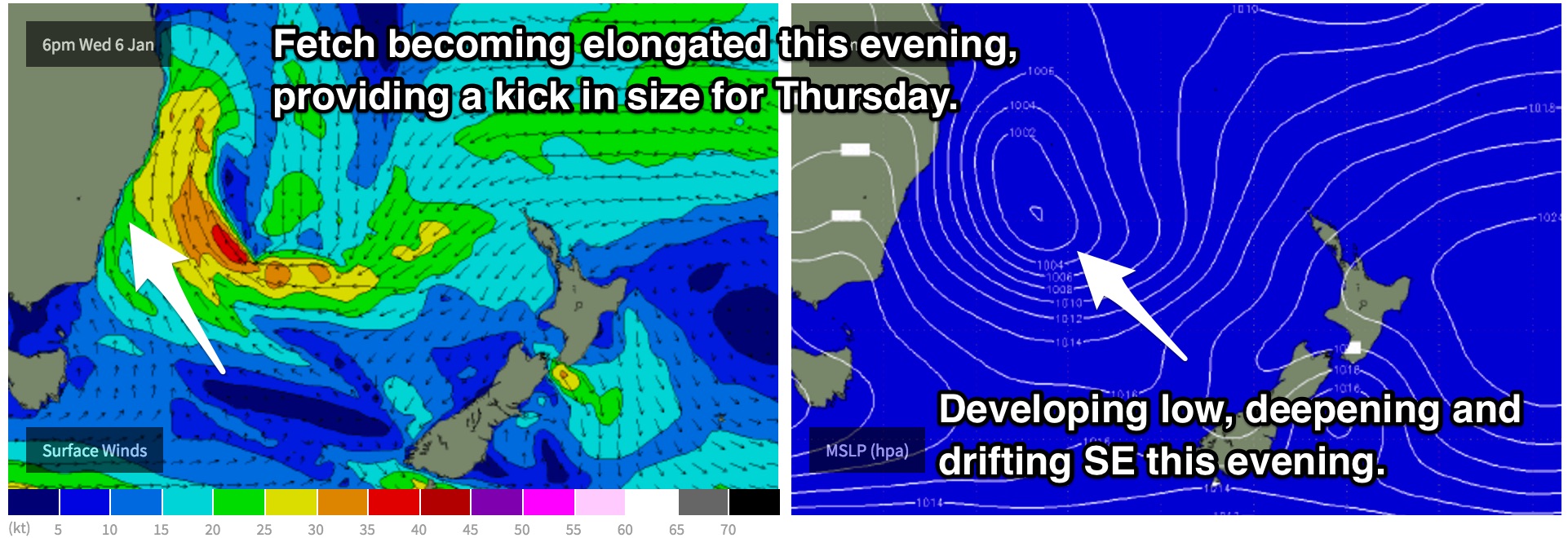
The Hunter is set to see surf in the 6ft+, possibly up to the 8ft range on Thursday, tapering off slightly along the Sydney and Illawarra coasts due to the less favourable alignment. Nevertheless, these coasts should still see a decent kick to the 5-6ft mark at south facing beaches.
Don’t get your hopes up without considering the wind scenario however, it’s not looking pretty. All coast are likely to be impacted by a fresh/strong southerly component airflow, particularly along the Hunter where winds may gust upwards of 70 km/h (similar to today). To make matters worse, this part of the coast is particularly exposed to the south and therefore holds very few options for a clean wave under a southerly regime.
Protected beaches along the Sydney and Illawarra coasts have a slightly better chance of a decent wave, particularly at southern corners as winds look to tend south/southwesterly for the morning session. Having said that, the strength of the breezes alone have the potential to still cause some issues, despite the slightly more favourable wind set up.
A second, less obvious source of swell is also likely to be in the water on Thursday, generated by Tropical Cyclone Ula which is continuing to grind away out near Fiji. Due to the long range nature of this east/northeasterly swell, consistency is likely to be an issue, that is if you can detect it amongst the more dominant short range energy.
Even so, open beaches should receive inconsistent sets in the 3-4ft range, less impacted by the breeze. This should help out those smaller, cleaner, more protected southern corners.
As the aforementioned low situated off the Mid North Coast drifts southeast, the intensity, proximity and alignment of this system will all become less favourable. Consequently, the surf is expected to fade throughout Friday from the 4-5ft+ range.
Meanwhile, that long range east/northeasterly swell should continue to provide inconsistent sets in the 3ft range across the open beaches, accompanied by another train of more consistent easterly swell to around 2-3ft generated by a Tasman ridge.
Winds are expected to be much lighter by this stage, with an opportunity for a workable wave in the morning under a light southwesterly airflow. As the day wears on, breezes should increase form the southeast and eventually east, having an impact on the quality.
This weekend (Saturday 9th - Sunday 10th):
A southerly groundswell is then due to build across the exposed south facing beaches throughout Saturday, generated by a frontal progression moving into the southern swell window late on Thursday.
While the broad west/southwesterly fetches of 35-45kts show poor alignment to the NSW coast, sideband energy should still allow the swell to build to around 3-5ft, with some good looking 16 second periods on the forecast.
After a night of light onshore breezes and a ridgey synoptic setup, the morning session looks good for light/variable breezes. As the swell builds, a northeasterly breeze looks to be on the increase, so the more beaches protected from the north will be the pick of the bunch.
Conditions should settle throughout Sunday, with the groundswell fading from the 3-4ft range, while the long range east/northeasterly swell of Ula keeps on keeping on, providing inconsistent options in the 2-3ft range.
Breezes aren’t looking all that special, but also not that bad. A light northeasterly flow is on the forecast throughout the day, but conditions should remain easily workable, particularly in the morning where winds have the potential to be calm/light/variable.
Next week (Monday 11th onward):
The northeasterly breezes developing on Saturday are part of a broader scale system, which should persist throughout the weekend and into early next week. We are looking at a small and relatively weak local northeasterly fetch hugging the coast.
Apart from weak groundswells generated by infrequent frontal activity, a small 1-2ft northeasterly windswell is likely to be one of the dominant swells in the water for Monday and Tuesday.
As expected, the breeze which is responsible for this swell will also impact the quality on Monday, while Tuesday holds better prospects for a wave, although still light onshore. If this is the only opportunity you have, make the most of the morning before breezes increase.
Comments
Still solid but slowly easing across the Northern Beaches.