Summer set up for the week ahead

Sydney, Hunter and Illawarra Surf Forecast by Guy Dixon (issued Monday 14th December)
Best Days: Early each morning for an small, ordinary wave.
Recap:
A southerly windswell was breaking across the coast on Saturday, slightly raw following the southerly change which created it. South facing beaches were options in the 4-5ft range, smaller on Sunday in the 3ft range. Conditions were workable early, deteriorating as the northeasterly breezes strengthened.
The surf has faded significantly this afternoon, with a small mix of residual southerly swell and a small, weak northeasterly windswell in the water.
This week (Tuesday 15th - Friday 18th):
The coming week is looking fairly slow, with the local swell windows being the only source of significant swell.
A strong blocking ridge looks to dominate over the Tasman Sea over the coming week, leading to prolonged periods of north/northeasterly fetches along the NSW coast, although not overly intense. This should provide a steady stream of small, peaky northeasterly swell for the open beaches along the NSW coast.
With the exception of tiny remnants of Sunday’s southerly groundswell on Tuesday, this northeasterly swell should hold in the 1-2ft range until Wednesday.
Winds look to be light/variable on Tuesday morning, soon tending northeasterly and persisting throughout the day. Wednesday holds a similar fate, with the early morning holding the best opportunity for a small, workable wave.
Thursday looks to bring a small increase in size across the open beaches, to around the 2ft+ range off a very slight intensification the day before. The wind scenario remains similar to the previous days, with a northeasterly breeze dominating for most of the day, lightest in the early morning.
Towards the end of the week, open beaches along the far South Coast may also see a slight increase in size to around 2-3ft as the fetch looks to be at its strongest off this part of the coast.
Meanwhile, open beaches along the Illawarra, Sydney and Hunter coasts should see peaks in the 2ft range under a persisting northeasterly breeze.
Any frontal activity looks to be weak, modestly sized and poorly aligned, so the impacts will be subtle and not worth much attention. South facing beaches won’t be offering many noteworthy options this week, however will be providing the best protection from the wind.
This weekend (Saturday 19th - Sunday 20th):
 Saturday is looking at a very slight increase in size from an intensification on Friday, with options in the 2ft+ range at open beaches. No prizes for the first person to guess the wind outlook - northeasterly and fairly gusty yet again.
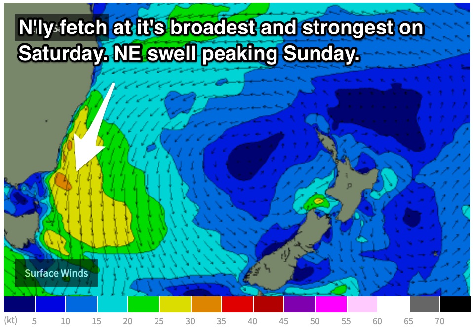
This northerly fetch looks to be at its strongest and broadest on Saturday, resulting in a peak in northeasterly windswell on Sunday to the 3ft range under gusty northeasterly breezes.
Next week (Monday 1st onward):
A southerly change looks to move through late on Sunday evening, into the early hours of Monday morning, with the window of workable offshore breezes likely falling during the overnight hours.
There is a good chance that models will adjust the timing of this change, so keep your fingers crossed for a window of offshore breezes during daylight hours.
In either scenario, Monday is looking at a building southerly windswell in the wake of a change, followed by a more substantial southerly groundswell later in the week.