S'ly swell over the weekend, peaky NE swell early next week

Sydney, Hunter and Illawarra Surf Forecast by Guy Dixon (issued Wednesday 9th December)
Best Days: Possibly Saturday morning, Sunday at south facing beaches and Monday morning.
Recap:
Easterly trade-swell was the dominant swell in the water across the NSW coast on Tuesday, with most spots picking up inconsistent sets in the 2-3ft range. The early and the late session were clean enough despite winds being light onshore, however the middle of the day was a bit soft and bumpy during the time of strongest breezes.
We have a mix of swells in the water today, with open beaches picking up the most action. A northeasterly windswell is providing peaky options in the 2-3ft range, while an easing easterly trade-swell is also contributing inconsistent sets to around 2ft. Finally, a southerly swell is struggling to make itself known at south swell magnets, but is forecast to provide options in the 2-3ft range.
This week (Thursday 10th - Friday 11th):
The end of the week is expected to see an easing trend as all swell sources fade. The easterly trade-swell will keep on providing inconsistent options in the 1-2ft range with the occasional 2ft set across exposed beaches on Thursday.
The ‘never say die’ attitude of this swell is largely as a result of the long duration of the swell generating system (tropical depression which developed into TC Tuni last week), but also the large distance from swell source to the east coast of Australia. All the effects of this swell take days to arrive.
A northeasterly windswell which peaked on Wednesday morning will continue to fade, although much faster than the aforementioned trade-swell. This is largely to do with the lower swell periods due to the local nature of the swell source. This swell developed quickly and is set to dissipate quickly, fading from the 1-2 range at exposed beaches during the day.
Finally south facing beaches are also expected to ease from the 2ft range off the back of today’s southerly swell, accompanied by a moderate southerly breeze during the morning, tending easterly and easing during the afternoon. Protected south ends of the open beaches are likely to offer the cleanest options.
Moving in to Friday, the only significant swell left in the water will be the easterly trade-swell which, by this stage, should only be in the 1-2ft range at open beaches.
Preceding a brisk southerly change, breezes looks to increase from the west, keeping the undersized line up super clean. Shame about the lack of size.
This weekend (Saturday 12th - Sunday 13th):
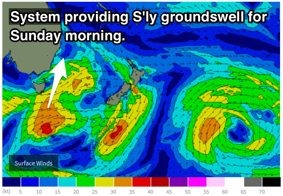
A cold front is set to move over the nation’s far southeast on Friday, steering a southwesterly fetch east of Tasmania and off the far South Coast of NSW late in the day. As these breezes move up the coast, a short range southerly swell is expected to build to the 3ft+ range across the magnets during Saturday.
 Despite local winds being light/variable during Saturday morning, there is the potential for conditions to still be a bit raw from the gusty southerly change the previous night. Never the less, the mid-morning session should allow for some workable options at south facing beaches, deteriorating late in the day as an east/southeasterly breeze increases.
Deep in the Southern Ocean, a slightly broader, more intense south/southwesterly fetch associated with this front is then expected to send a pulse of longer period southerly swell up the NSW coast. This swell is expected to peak on Sunday morning in the 3ft range at south facing beaches, with the outside chance of the occasional 4ft bomb, fading thereafter.
Protected northern corners of south facing beaches will be the way to go on Sunday. Here you’ll find protection from an increasing northeasterly breeze while picking up good energy of the southerly swell. Elsewhere is likely to be wind affected and bumpy.
Next week (Monday 14th onward):
The aforementioned northeasterly breezes on Sunday are associated with a broader scale north/northeasterly fetch, which is due to set up along the NSW coast on Sunday. This fetch is expected to provide a peak in northeasterly windswell for Monday morning.
The fetch itself is not overly large or powerful, however its alignment is good, hugging the coast during Sunday before moving offshore on Monday morning leading to peaks in the 2ft+ range.
As this fetch moves offshore, breezes have the potential to tend west/northwesterly for a period during Monday morning, leading to clean, peaky A-frame across the open beaches to start the week.
Some models have a brief period of a more north/northwesterly airflow before the northeasterly breeze kick in once again during the afternoon.
Time will allow models to come into alignment one way or another.
Also in the mix should be small remnents of Sunday's southerly swell, fading from the 2ft range.
Each swell is then due to fade throughout Tuesday, with open beaches easing from the 2ft range, smaller elsewhere.
The out look for the remainder of the week looks fairly bleak, with no real indications of fresh significant swell.
Comments
This east swell keeps on delivering! A few small lines at Manly.