Friday morning looking good

Sydney, Hunter and Illawarra Surf Forecast by Guy Dixon (issued Wednesday 4th November)
Best Days: Possibly Thursday at south facing beaches and Friday mid-morning
Recap:
Conditions were small and lacklustre right along the coast on Tueday with small remnants of a northeasterly swell in the 1-2ft range under a southerly flow. There wasn't much on offer throughout the day apart from small, bumpy slop. Today, we woke to workable surf in the 2ft range which rapidly increased to the 4ft range generated by a strong, loacl easterly fetch. Unfortunately the quality dropped with a gusty onshore flow, however there were punchy waves for those who tried.
This week (Thursday 5th - Friday 6th):
We are still on track for a dynamic few days as the pressure gradient tightens between a strong Tasman ridge and a deep trough over inland Australia.
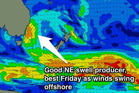 An easterly fetch which has been increasing along the coast of NSW today will tend northeasterly overnight and strengthen throughout Thursday. Strong/gale force breezes are expected to blow along the coast on Thursday whipping up a solid northeasterly wind swell, not to mention the easterly energy that is already in the water.
The surf should build to the 4-5ft range across open beaches of the Sydney coast on Thursday, larger along the South Coast, although the quality will be pretty ordinary for most spots. Only the most protected northern corners of south facing beaches will be offering workable conditions, but smaller due to the swell direction.
Having said that, the Batemans Bay buoy has just picked up a southerly groundswell which is set to provide options in the 2-3ft range at south facing beaches. This swell will provide good options out of the wind, although has the potential to be fairly inconsistent at times.
Moving into Friday, it looks as though this fetch will have moved offshore, allowing the surf to fade slightly by sunrise. As a result, I'm inclined to think that the surf will be in the 3-5ft range by daybreak, however some models have the fetch hugging the coast until the early hours of the morning, which would keep the surf in the 4-5ft range.
The surf will fade steadily throughout the day, however as a change moves through, we are looking at winds becoming favourable and prospects of great surf.
At this stage, It looks as though winds will tend northwesterly along the Illawarra during early/mid morning, more like mid morning for the Hunter. It should take a few hours for these breezes to iron out the bumps, so late morning is looking like a good window of opportunity for fun, peaky a-frames.
If this change stalls, the window of opportunity will shift later in the day.
Again, there will be small 2ft southerly energy in the mix, however it’s significance is less due to the abundance of better options on offer.
This weekend (Saturday 7th - Sunday 8th):
Remnants of Thursday/Friday’s northeasterly wind swell will be the only real sources of surfable energy on Saturday morning, however, south facing beaches are expecting an increase of low quality swell throughout the day.
A weak southerly change is expected to move up the coast late on Friday evening and overnight into Saturday whipping up short range energy, peaking in the afternoon. South facing beaches should build into the 3ft, however the quality is looks poor due to local southerly breezes.
Longer period southerly energy will also be in the mix generated by more substantial fetches at the base of this system, however winds will remain an issue.
The best options will be small residual east/northeasterly energy in the 2ft+ range at the more protected open beaches. Even then, don’t get your hopes up too much.
Sunday isn’t looking much better in terms of swell. We will have to rely on small residual southerly energy left over from Saturday which is only expected to provide weak options in the 2ft range at south facing beaches in the morning, easing throughout the day.
On the plus side, conditions should be workable in the morning under a light/variable-southeasterly flow. Hit it early however, this way you’ll make the most of the light winds before the swell fades.
Next week (Monday 9th onward):
The swell window looks to remain fairly dormant for the first half of next week, however there is the chance of a small southeasterly swell in the 2ft range for Tuesday generated by a modest, but elongated southeasterly fetch sitting off the southern tip of New Zealand.
The next chance of surf comes on Thursday as another northeasterly fetch sets up. Have a look at the long-range WAMS for details. More info on Friday.
Comments
Looking fun in Newy this arvo.
Have to admit, even Bondi looked decent this morning. Here's to tomorrow's NW winds arriving early to clean up some more exposed spots.
Any changes to the forecast for tomorrow morning around the northern beaches area?
It's looking good. NW breezes for the early session. Hoping for a few hours of NW before dawn to iron out this evening's NE bump.
It has been blowing NW since 3am thank you Guy for the great reports.