Average weekend ahead, large and windy next week

Sydney, Hunter and Illawarra Surf Forecast by Ben Matson (issued Friday 18th September)
Best Days: No great days... yet. There'l be plenty of size through the middle to latter part of next week but it's likely to be quite windy too. Will have a better idea Monday.
Recap: Plenty of southerly swell over the last few days. Thursday was a solid 3ft at south facing beaches, and today came in a little bigger with 3-4ft bombs at some locations however aside from a short window of early offshores on Thursday (and an even briefer window of SW winds this morning), freshening southerlies have generally created very ordinary conditions across most coasts.
This weekend (Sep 19 - 20)
No major changes to the weekend forecast.
We’re looking at another round of southerly groundswell into Saturday, but it’ll probably be a little smaller than what we saw today. Most south facing beaches should see 2-3ft sets, with bigger waves on offer in the Hunter, but the main concern on Saturday are the local winds: a building high pressure system in the southern Tasman Sea is expected to drive a moderate SE airstream across most regions.
There’s an outside chance for a period of early W/SW winds at a few locations early morning, but I’m now a little less confident than earlier in the week, as the models have slightly strengthened the ridge closer to the coast than previously estimated. As such, keep your expectations low for any major quality.
This ridge will also generate a short range E/SE swell for the region that’ll slowly build on Sunday. Wave heights should hover somewhere between 2ft and very occasionally 3ft at most open beaches throughout the day (the E/SE direction likely to favour a wider range of locations), but again we’ll be at the mercy of local onshore winds, and the surf will also be much more tidally dependent, being short range windswell. Winds are not expected to be very strong - developing E’ly through Sydney and NE along the South Coast - so there is certainly a chance for a period of light variable winds at dawn, but on the whole expect these winds to create slightly bumpy conditions at open beaches throughout the day.
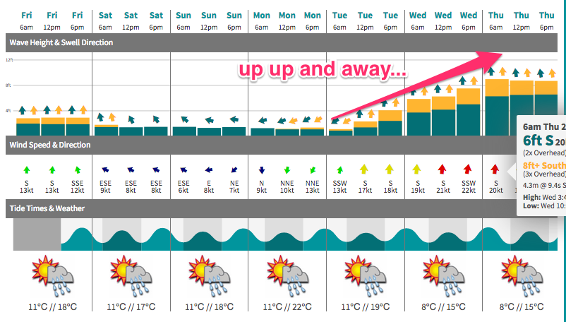
Next week (Sep 21 onwards)
We’ve got a few changes to the long range outlook for next week.
First of all, Monday is still looking at a fresh SE swell originating from a low that’s developing off the SW tip of New Zealand’s South Island today, however the primary fetch has been focused a little off-axis in the latest model runs and is now aimed at points north of Sydney. Still, it’s a pretty good sized fetch and should kick up 2-3ft sets throughout the day (there may be a slight lag on this swell early morning).
Additionally, there’ll be a small trade swell in the mix from the weekend’s ridge through the Tasman Sea, and freshening N’ly winds will whip up a small NE windswell - but also create some problems at open beaches. So, find a sheltered northern corner and you’ll do OK on Monday (preferably in the afternoon as the SE swell reaches a peak).
Unfortunately, the great E/SE swell we’ve been expecting for Tuesday and Wednesday has been almost completely wiped off the charts.
It was forecast to be generated by the same low pressure system (mentioned above for Monday’s swell) as it moved northwards over the weekend, merging with another trough/low that formed well east off the Byron Coast today.
Unfortunately, the Byron low has decided to remain where it is, and the NZ low is now forecast to move slowly eastwards - over land. So, the landmass of New Zealand will now bisect this system in two, and also rearrange its alignment so that there’s very little fetch aimed in our swell window.
It’s amazing what small aberrations in model data can result in - and unfortunately in this case it’s a non-event for our expected mid-week swell.
Nevertheless we still have a dynamic week of waves on the way for the middle to latter part of the week. A gusty S’ly change is expected to push up the coast on Tuesday morning, linked in with a broad, strong frontal passage stretching all the way down to polar latitudes.
A blocking pattern upstream - in fact, the same low we were initially hoping for our Tues/Wed swell is now expected to re-intensify east of New Zealand - will then stall the west-east migration of weather systems in our region, and allow this next pattern to develop considerably across the western Tasman Sea.
At this stage it’s too early to pin down specifics, as we’re looking at quite a comprehensive, long lasting feature to reside in our swell window. But the upshot of it is that we’re going to see a lot of south swell building from Tuesday onwards, and there’s a chance for an embedded low pressure system or two in the mix that could really supercharge things and allow very large swells to develop (later in the week).
So for now, let’s just assume it’s a one way street from Tuesday - building southerly swells that is - but with fresh and gusty accompanying southerly winds. By Thursday or Friday, we could be looking at an additionally large E/SE swell depending on how a (modelled) low forms off the coast, but there certainly won’t be any shortage of size - I’d be surprised if it didn’t reach at least 8ft by the week’s end, maybe even more. And next weekend should see plenty of surf too although we’ll likely be on the downwards phase of this event by then.
Have a great weekend.. see you Monday!
Comments
The fog's been slowly pushing into Cronulla all morning.
Is that a large baitball out the back at Bondi?
Cheers Ben. I've got two 16 yr old lads to entertain Thurs/Fri. They are 'competant' but by no means lugging around balls of steel. Looking forward to taking them camping either three hours south or three hours north. Any counsel for the Volvo wagon yet to be laden?
Will have the updated forecast up just before 5pm TUT. This week's forecasts are being prepared by Guy, our newest addition to the Swellnet forecasting team - he's been doing a great job with WA and we had a chat about the upcoming situation this week so he's right on top of things.
Great Stuff & Much Appreciated. I always enjoy the forecast and the charts. The joy of choice we have in NSW that the lands of the Piping Shrike aren't always blessed with.