Period of small surf ahead, next swell due late Thursday

Sydney, Hunter and Illawarra Surf Forecast by Ben Matson (issued Monday 10th August)
Best Days: Tues: get in early before the south swell disappears. Fri: fun mix of south swells with good winds. Sat/Sun: small clean south swell(s) with light winds. Next week (prob Tues-Thurs): strong southerly groundswell.
Recap: A pumping south swell provided great waves across the southern NSW coast on Saturday, Sunday and Monday. Wave heights reached a peak late Saturday in the 5-6ft range but remained strong through Sunday although easing a little; even this morning was a little bigger than expected with 3ft+ sets at most south facing beaches and clean conditions under an offshore breeze. Hope you got some.
This week (August 11 - 14)
So, right now we’re on the backside of the weekend’s south swell.
There are no new swell sources expected to develop within our swell window until Thursday morning, so the surf forecast for the next few days is simply a continuation of this current easing trend - Tuesday morning will have the most size, but estimating just how much is a little difficult as surf has been performing slightly above model expectations today.
This doesn’t necessarily mean that tomorrow will perform the same - swell phases are nonlinear - so it could very well become very smaller, much more quickly than expected.
That being said, I think we’ll probably see some leftover 1-2ft waves at south facing beaches early Tuesday morning, with a few bigger bombs in the Hunter, with smaller conditions settling in throughout the day.
Wednesday’s likely to be tiny, near flat and both days will be clean with light to moderate (Tuesday) tending fresh and gusty (Wednesday) W/NW winds.
These winds will be related to the passage of several cold fronts across the state, all of which will be riding quite north in latitude. Early Thursday morning, the Long Wave Trough will push off the East Coast, and this will allow the trailing winds behind the next front(s) to tend more SW in alignment, meaning they’ll be in a better position to generate swell.
In fact, we’ll see two fronts simultaneously develop inside our southern swell window - one off the Far South Coast, and another just SE of Tasmania. The South Coast front will generate a short range swell for Thursday afternoon while the Tasmanian front will generate a slightly better south swell for Friday.
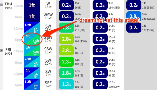
Estimating wave heights from these systems is a little hard. I think out surf model is overcalling size for Thursday’s swell (currently 5-6ft at south facing beaches at 6pm, see below) - I think we’re probably looking at around 4ft at south facing beaches very late in the day, starting from a tiny base early morning - probably no major movement before early afternoon.
Friday’s slightly better groundswell should hold in a similar size range, however there will be - as per usual - a massive variation in size across the coast, with tiny waves expected in southern corners (the Hunter should do a little better in the size department though, particularly Friday).
Friday is probably the pick of the forecast period as Thursday’s late increase is likely to be accompanied by a wind swing from the W/SW to the SW then S/SW, so open beaches picking up the new swell will be rather bumpy. Friday should see better conditions as the front clears to the east (allowing the pressure gradient to relax), but the timing on the next pulse is unclear - at this stage I don’t think it’ll be in the water early morning, but should be there from about lunchtime onwards.
Therefore, the early session on Friday may be a little undersized, as we’ll be between swells (say, 2-3ft south facing beaches) but conditions are expected to remain favourable for most of the day.
Let’s take a closer look on Wednesday to see how this south swell is panning out, and whether and upgrade and/or improvement is likely.
This weekend (Aug 15 - 16)
Nothing major on the cards for the weekend at this stage.
Friday’s south swell will ease slowly through Saturday, and as for new swell sources - a couple of weak fronts will nudge the lower Tasman Sea, and probably push up some small energy but nothing to break the bank.
It’ll probably just be enough to keep the open beaches from becoming flat; at this stage a round figure in the 2ft range at south facing beaches both days (perhaps a little bigger early Saturday) seems about right. Winds should be light too. Let’s check back Wednesday to see if things have changed.
Next week (Aug 17 onwards)
A series of powerful Southern Ocean fronts/lows are expected to track under Tasmania starting next weekend, and will generate some excellent long period southerly groundswell for the region next week.
I’m a little concerned that the storm track will be quite zonal to begin with, which will probably shave a lot of size off the surf potential however by the first few days of next week, strong secondary fronts tracking behind should start to push through the swell window with a better orientation, which should generate some really good surf for the middle to latter part of the week.
At this stage it’s too early to pin down the specifics, so without wanting to be blasé about next week’s surf prospects I’d casually pencil out Tuesday to Thursday next week and start planning for some solid clean waves at south facing locations. More on this in Wednesday’s update.
Comments
Todays Newy pics..........The Norris sisters .....they absolutely shred - surfing and skating.
Very cool, how's this little slice back into the pocket!