Small weekend; then a wide range in S'ly swell next week and beyond

Sydney, Hunter and Illawarra Surf Forecast by Ben Matson (issued Friday 31st July)
Best Days: Tues/Wed: fun S'ly swell with good winds. Thurs/Fri/Sat: large S'ly swell, with periods of good winds (Fri the pick at this stage).
Recap: Thursday morning offered some fun waves with the early/mid-week south swell easing slowly in size. During the afternoon, the MHL buoys picked up a new long period south swell as expected (Tp around 18-19 seocnds), and it’s provided occasional 2ft waves across the coast today (a little bigger in the Hunter) with clean conditions under a light variable breeze. I even spied a few bigger bombs on the Bondi cam at times today too.
This weekend (August 1 - 2)
A weak front pushed through the southern Tasman Sea this morning, but it wasn’t quite as strong as model data had suggested so the small late pulse I was expecting right on dark (this evening) probably won’t eventuate to any great degree. However, we may see some lingering southerly groundswell - from today's long period event - early on Saturday, as it slowly eases.
As such, I’m not expecting much size on Saturday - just an inconsistent 1-1.5ft at south swell magnets early morning, fading into the afternoon, and tiny to flat conditions elsewhere. The Hunter may see a few bigger 2ft sets but they’ll be very far and few between. Winds are expected to freshen from the N/NW into the morning before tending NW during the afternoon. So, if you’re desperate for a paddle aim for the most reliable south swell magnet you can think of, and make sure it favours some form of northerly wind. The afternoon may also see a tiny level of NE windswell at exposed NE facing beaches (originating from the local northerly flow) but it’s not worth getting excited about.
Unfortunately, the front modelled to push through the southern Tasman Sea on Saturday has been weakened slightly, and also focused a little less favourably through our swell window in a more zonal pattern (west-east).
As such, this has almost completely wiped out the chances for anything worthwhile across Southern NSW on Sunday. We may see a foot plus of small, refracted swell at south facing beaches (again, a little bigger in the Hunter) but I have a feeling most beaches will be near flat on Sunday. Winds are expected to remain NW through the morning but may tend N’ly for a period during the middle of the day.
So, don’t expect much surf this weekend - if you have to get wet, aim for an early paddle on Saturday.
Next week (August 3 - 7)
This incredible series of fronts I’ve been discussing all week is still on track, but for Southern NSW it’s proving to be a little elusive to pin down the exact swell potential.
The main problem is that the primary storm track is mainly west of Tasmania, so most of the initial swell generating fetch is being steered up into Vicco and SA. Successive model runs have shunted it east, then west, and also pushed back the final phase of the LWT, which makes it hard to get a grip on exactly when we’ll see a solid swell event in our waters.
Therefore, because of all of these model changes, I’m not totally confident on the outlook for next week. I’ll update in the comments below over the weekend if confidence does increase but for now take all of the info below with a pinch of salt.
At this stage the first front is expected to push into our southern swell window - just east of Tasmania - on Monday morning. Whilst we may see a minor increase in refracted southerly energy during the day (from a fetch trailing the initial front, say 1-1.5ft south facing beaches), the bulk of this swell won’t arrive until Tuesday. The most likely scenario here seems to be somewhere in the 3-4ft+ range across south facing beaches, with bigger bombs in the Hunter. Winds should be pretty good on Tuesday, mainly light from the western quadrant.
The swell window is expected to then temporarily shut off during Tuesday as another strong front rears up from the SW, which means we’ll see declining wave heights through Wednesday. Early 2-3ft sets at south facing beaches (bigger in the Hunter) may be on offer but expect smaller surf throughout the day as wave heights ease. It’ll be clean under freshening NW winds though.
Another major low/front combo will then drop off the Southern NSW coast early Thursday morning. Whist the dawn patrol will probably start off quite small, we should see a rapid increase in short range S'ly swell throughout the day, with maybe some 6-8ft sets at south facing beaches in the few hours before dark.
Winds will however tend strong SW thru’ S/SW as the swell reaches a peak so the only options will be at locations offering some shelter from these conditions.
Another series of fronts (probably two more) are then expected to maintain vigorous activity inside our south swell window for the second half of the week, which should keep wave heights quite large through Friday, probably in the 6-8ft range at south facing beaches again. However conditions look a lot better by this time with winds tending lighter W’ly across many regions in the morning, possibly SW through the afternoon.
Keep in mind that for the entire duration of this southerly swell, wave heights will be considerably smaller at beaches not open to the south. But there’ll be some large surf on offer for those who enjoy the big stuff.
Next weekend and beyond (August 8 onwards)
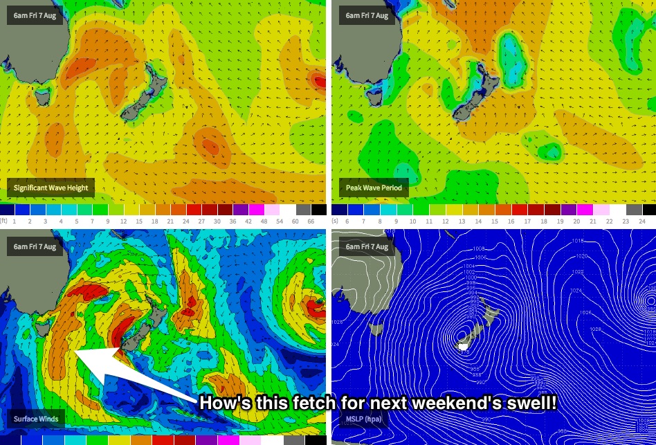
Based on current model guidance, the strong southerly swell expected later next week should hold into Saturday before easing Sunday. In fact this potentially may deliver the best swell of the entire sequence, as it'll be sourced from polar latitude thanks to the LWT finally pushing east of Tasmania, allowing for a very long southerly fetch to develop within our swell window (see chart below). But, we may also be at risk of a more SW tending S'ly airstream. More on this in Monday’s update.
Comments
That synoptic pic looks a bit better than the models I was looking at in the 0000 update, so that's good.
Final position will determine whether we look like getting fairly light sou west winds, which would have lots of reasons to go south, or southerly gales, making a trip down south less desirable.
Hey Black Duck, you out there? I'll let you know if I can get down your way.
Hey Ben just to let everyone know, the warm water honeymoon is over. It's brass monkey temperature now in the Illawarra . Keep them south swells coming Ben. Cheers!
You're right - the Sydney buoy is still just over 18 degrees but Pt Kembla is down to 16 degrees. Still better than Vicco though.. 12.7 degrees at Point Nepean. Rubber up!
too cold for the springy
Wore boardies and vest while bodybashing at Thirroul yesterday and today. Needed a mid-arvo wake up and it was better than a triple-shot cap.
you are breed differently Stu!
looks like a new SSE swell turned up late yesterday and is hanging around this morning. the buoys seem to suggest that.
It actually arrived late Thursday and was in the water all day yesty (as detailed in the notes) and was still in the water this morning.
makes sense, sort of, i didn't see the beach late on Friday, i assumed from the MHL data that it went flat.
looking at the wave heights on the MHL site it shows an increase late, as in after dark, yesterday. what was that, the same swell but just a bit more height?
i can see the period jumped on Thurs at about lunchtime...
maybe i'm holding it upside down.
Nah, Friday was an inconsistent 2ft all day. Even managed to capture a good 3ft set on the Bondi surfcam late arvo:
Anyway, as per the image below you can see that the leading edge arrived Thursday lunchtime. Typically with these distant polar swells the bulk energy is located some 18-24 hours behind, (in this case, it seems the bigger sets arrived later Friday, which is 30 hours behind the forerunners). We saw waves persist right through the first half of Saturday too, even this morning had a few trailing lines in the 1ft range - sure, not very large in size - but it's still 1/3 to 1/2 of the original size, which is a healthy percentage considering it was almost three full days after the leading edge arrived..
As for the buoy data: because there wasn't much synoptic wind on these days, we can be confident that the buoy data is primarily groundswell energy (ie not contaminated by local windswell).
Looking at the trace (below), and you can see that all day Thursday, Tsig (significant wave heights) fluctuated considerably, from 10s down to 7.5s.. this is typical of a long range groundswell source, and usually suggests long lully periods. Ordinarily, in the absence of any local windswell contamination, Tsig would be much more steady.
that's awesome, thanks.
i always figured the period was important but this gives me a new perspective.
Still a few tiny peelers at Bondi.