Easing S/SE swell; small NE swell, then a run of onshore winds

Sydney, Hunter and Illawarra Surf Forecast by Ben Matson (issued Monday 15th June)
Best Days: Tues: good, easing S/SE swell but with tricky winds. Wed: small NE swell with offshore winds. Fri/Sat: strong S'ly swell but winds look dicey.
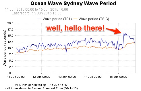
Recap: Plenty of fun surf across the region over the weekend, up to 3ft in Sydney on Saturday (bigger 4ft sets in the Hunter) and smaller through Sunday. Both days had favourably light winds. A new S/SE groundswell expected to arrive this afternoon has pushed through earlier than expected (the Sydney MHL buoy picking up peak swell periods of 16 seconds this morning), and has produced very good 3-4ft surf across the region today under a light variable wind regime.
This week (June 16 - 19)
With today’s S/SE swell arriving a little earlier than expected, it’s fair to assume that we’ll probably see the backside of this event a little earlier than Friday’s forecast anticipated. We may see some early 3ft+ sets at south facing beaches very early Tuesday morning but they’ll probably be quite inconsistent and are expected to ease further throughout the day.
The freshening NE flow expected over the coming days has also been brought forward a little, and is expected to be more N’ly in direction. It’s now expected to develop overnight tonight and will consequently dominate Tuesday’s surf conditions.
In fact, as well as creating bumpy problems away from the most protected south swell magnets, we’ll also see a building NE swell throughout the afternoon - nothing special but certainly some low quality energy in the 2ft+ range at NE facing beaches by the end of the day. However with accompanying fresh NE tending N’ly winds conditions won’t be great at these locations. The Northern Hunter rarely does well under these NE windswells so don’t expect much size here.
It’s also worth pointing out that the models have a much stronger NE fetch aimed into the Far South Coast (compared to the Sydney/Illawarra/Hunter) so we will probably see bigger waves south of about Ulladulla (3-4ft) by late afternoon.
Wednesday looks like a slightly better day for surf prospects. Although the NE fetch in our immediate swell window is expected to last only a short time, a broad but still only moderate NE fetch spanning much of the western Tasman Sea through Tuesday afternoon should generate a second NE swell for Wednesday. At this stage I’m not expect much more than 2ft+ sets at NE swell magnets (the south swell will be very small by this time) however conditions should be much better with freshening NW winds tending W’ly during the day. I'm also not confident on the timing of this second swell so wave heights may lag early morning.
This freshening NE tending N’ly, NW and then W’ly through Tuesday and Wednesday is all related to the development of a broad coastal trough. Once this pushes off the coast around Wednesday, we’ll see a low form and a subsequent southerly flow push up through the southern Tasman Sea. This is expected to build a new south swell for the region, with freshening W/SW tending SW then S’ly winds on Thursday and average, bumpy sets of about 3-4ft+ at south facing beaches by the afternoon.
This south swell will then reach a peak through Friday but local winds look dicey thanks to a stalled trough off the Mid North Coast that’ll probably maintain fresh and gusty S/SE winds about most regions. We may see 4-6ft surf at south facing beaches but the only rideable options under this wind regime will be at protected southern corners (which will be much smaller, owing to the relatively near source of the swell and the short swell period).
So, at this stage Friday - and even some of Thursday - looks like finishing off on a wet and windy note. Make the most of the next few days for the best surf of the working week.
This weekend (June 20 - 21)
The broad outlook for the weekend right now is easing onshore winds through Saturday, and moderate SE swells, with lighter winds and easing surf through Sunday.
The stalled trough progged for Friday may develop a new surface low off the North Coast, and in doing so will probably concentrate most of its energy towards that region for Saturday morning. But the lingering S/SE flow across Southern NSW really won’t do many favours for our surf potential, which is a shame as a small secondary low forecast off the SW tip of New Zealand’s South Island on Thursday afternoon is likely to generate a fun round of SE swell for Saturday, probably in the 3-4ft range. This is in addition to a solid but easing short range swell from the local S/SE wind.
Smaller surf is then expected Sunday as all swell sources ease, and local winds become light and variable under a migrating high pressure system. Let’s take a closer look at this on Wednesday.
Next week (June 22 onwards)
Nothing major on the cards for next week at this stage, just the bog standard frontal progression through the lower Tasman Sea that should provide enough southerly energy to keep us running. Otherwise, it’ll also be worthwhile keeping an eye on the North Coast low (on Friday) to see if there are chances of a regeneration over the weekend as it tracks eastward to one of our favourite swell windows - the waters off the west coast of New Zealand’s North Island. This is however a very optimistic long range outlook, so let's see how Wednesday's model runs are panning out.
Comments
Hmmm, Sydney buoy has picked up Tp of 17 seconds a short time ago (after falling away from this morning's spike of 15 seconds). Suggests perhaps a little more size around tomorrow morning but I'm not very confident that this will happen (I won't change the forecast notes above, either).