Lots of large south swell on the way

Sydney, Hunter and Illawarra Surf Forecast by Ben Matson (issued Monday 11th May)
Best Days: Tues: fun south swell with offshore winds. Thurs/Fri/Sat: large south swell but windy from the SW thru' S.
Recap: What a weekend of contrasts. Saturday’s long period south swell delivered a wide range in wave heights, anywhere from 6ft+ in the Hunter, through to 3-4ft at Sydney’s south facing beaches, and much smaller surf elsewhere. This swell eased late in the day and rapidly overnight, offering much smaller waves for Sunday, although the Hunter still pulled in 3-4ft surf. Elsewhere, Sydney’s south facing beaches dropped below forecast expectations to 1-2ft, and it was almost flat at remaining beaches. Today has seen tiny to flat conditions persist across the coast but a new S’ly swell is expected to push along the coast late in the day and we may see some late lines at south facing beaches on dark.
This week (May 12- 15)
So, right now there’s an impressive W/SW thru SW fetch of gales existing eastern Bass Strait, courtesy of a vigorous front that crossed the region overnight. Although it’s not aimed very well towards the southern NSW coast (in fact it’s mainly pointed away from us!), the sheer strength, width and sustained nature of this fetch means that we’ll see a decent level of sideband energy push into the coast over the coming hours.
Most of it will fill in overnight so early Tuesday morning will have the biggest waves - we’re looking somewhere between 3ft and maybe 4ft at exposed south facing beaches in Sydney, but the Hunter coast always does much better from these swells and should pull in 4ft to almost 6ft surf.
However, beaches not open to the south - and remember, that's most of 'em - will be much smaller (in fact it could very well be tiny to flat at some protected beaches). Expect a steady easing trend during the day from mid-morning onwards.
Also worth pointing out that due to the position of this fetch, we’ll also see smaller waves along the South Coast due to the way in which swells spread away from their primary source. There’s an axis point along the southern NSW coast (usually somewhere in the Jervis Bay thru’ the Illawarra region) whereby to the south of this location, wave heights will be much, much smaller - even at exposed south facing beaches. So keep this in mind if you’re located south of Wollongong.
As for local conditions on Tuesday, we’re looking at fresh W/NW airstream so most locations should be nice and clean. Just aim for the morning session for the biggest waves.
While this is all happening, a much deeper, more powerful low is expected to cross the Tasmanian region - probably the biggest weather system we’ve seen in this neck of the woods all year. However, it’s expected to initially display W’ly through W/NW winds across our swell window. As such I’m not confident that we’ll see much energy from this particular part of the storm. It’s a real line-call (and a shame too, as winds are expected to be 50kts+ just north-east of Tasmania late Tuesday) but I really think that we need another ten degree counter-clockwise swing in the fetch alignment before we’d see any appreciable swell across southern NSW.
That being said, wave heights probably won’t go flat on Wednesday (like they have today). A moderate polar low well south the Tasman Sea today extends a broad SW fetch up into our swell window and should maintain inconsistent 2ft waves at south facing beaches throughout the day (a little bigger in the Hunter). Freshening W/SW winds in the morning will keep conditions clean but a gusty SW flow is expected to develop after lunch. Expect long breaks between waves.
In fact, this (developing) local SW fetch should contribute a bigger but very late increase in south swell across the coast. It’s not expected to form properly off the South Coast until mid-late morning, so it’s hard to imagine much of an increase showing across Sydney’s south facing beaches before about 3-4pm, but the last few hours of the day should see occasional 3-4ft+ sets at these exposed locations. However the wind may also be into it at this time, so keep your expectations low (as per usual, it’ll be much smaller at beaches not completely open to the south).
As the primary storm track shifts into the Tasman Sea on Wednesday, we’ll see a complex fetch of southerly winds develop across the entire south swell window. Several low pressure centres will each contribute strong energy from Thursday through Friday, and on the whole we’re looking at very large surf in the 6-8ft range (south facing beaches) by Thursday afternoon and into Friday morning (it’ll be bigger across the Hunter near 8-10ft at the height of the swell). Fresh to strong SW winds will tend S/SW during the days so you’ll have to hunt for some protection. Wave heights are expected to then ease through Friday afternoon.
This weekend (May 16 - 17)
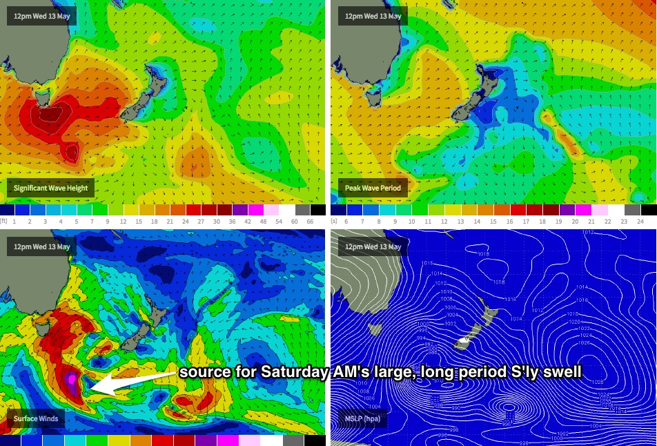
For my eyes, the best feature of this upcoming weather pattern is a polar low located at the bottom of the parent system (developing Wednesday) that’s expected to rocket up through our south swell window over the following days. This is expected to generate a large, long period southerly swell that'll arrive overnight Friday, and should be in the water for Saturday morning. At this stage, surf size will probably push slightly higher than what we’re expecting later this week, if the latest model guidance holds true.
At this stage I’m expecting a solid 6-8ft+ across Sydney’s south facing beaches, and 8-10ft+ in the Hunter, with an easing trend into the afternoon. Early indications are that we’ll still be under the influence of a fresh SW tending S’ly airstream, but I’ll fine tune these details on Wednesday. Nevertheless you’ll probably be sniffing out somewhere smaller and more sheltered on Saturday.
After that, we can expect rapidly easing swells and winds through into Sunday, but still with more than enough size to deliver something for everyone.
Next week (May 18 onwards)
Nothing major on the cards for next week at this stage, which is good as it’ll allow us to focus our attention towards the upcoming extended run of south swell. See you Wednesday for more fine tuning.
Comments
Small lines now showing at Bondi (emphasis on the 'small').
Outer reefs
hey guys. reckon any of these lows passing beneath us will wind up nicely on the other side of new zealand and give mexico any swell friday onwards?
Man o man I thought watching S swell sail past the mbah buoy was frustrating, it's equally so here in the big smoke cos driving travel times and daylight is so restrictive!
"Nothing major on the cards for next week at this stage, which is good..."
No, no, no, no, no! Not good Ben. I'm heading over to the east coast for a week next Monday, based at Freshie/Queenscliff. Nothing major on the cards is BAD news.
I was hoping you boys could rustle up a 2-3 metre SE swell and light SW winds for pretty much the whole week. Not too much to ask, surely?
It was very small this morning, but the south swell started to show mid-morning and there's now some fun sets at south facing beaches.