Lots of swell due this weekend, but with tricky winds

Sydney, Hunter and Illawarra Surf Forecast by Ben Matson (issued Wednesday 29th April)
Best Days: Fri: good S'ly swell but local winds are tricky. Keep your expectations low. Sat: building E/NE swell but local winds will (again) likely create problems. Keep your expectations low. Sun/Mon: Strong E/NE swell and improving conditions as winds become light and variable. Wed: new S'ly swell. Next Thurs/Fri/Sat: another strong E/NE groundswell.
Recap: Plenty of easing S’ly swell Tuesday with early light winds ahead of a developing southerly. Much smaller leftovers today - smaller than expected - with early offshores in a few places (i.e. Northern Beaches) but overall, not a patch on recent offerings. Winds swung onshore this afternoon too.
This week (Apr 30 - May 1)
Mediocre, probably tending poor. That’s the topline forecast for the rest of the week.
We’ve got a small pulse of southerly swell due into the coast early Thursday morning, offering 2-3ft sets at south facing beaches (bigger in the Hunter) but winds are expected to freshen from the south-east so conditions will be generally quite average. I’m not even convinced that we’ll see a local period of light offshore winds in a few selected areas either - the synoptic flow, despite not being overly strong, will probably override these local influences. So keep your expectations low foranything decent on Thursday.
Friday looks very tricky, thanks to a developing trough along the entire eastern seaboard that may also spin up an East Coast Low off the North Coast.
Surf wise, we’re now not expecting any appreciable ENE swell until the weekend, although there will be a small, slow increase in short range energy during Friday as a broad E/NE fetch feeing into the trough strengthens.
Probably of more importance on Friday will be a secondary pulse of S’ly groundswell from a deep Southern Ocean low that’s currently crossing the region just south of New Zealand. Although unfavourably aimed into our swell window, the associated SW fetch was quite impressive (broad, long and very strong) and this is expected to generate a good pulse of S/SE swell for most of the day, upwards of 3ft at south facing beaches (and maybe bigger in the Hunter). It may be a little inconsistent though.
The tricky part for Friday revolve around the local winds. As is common with complex surface troughs, there’s a chance that local winds along the coastal strip will defy model guidance - most of which is pointing to a freshening E’ly airstream all day. As such there’s no way of having any confidence in what might eventuate - I’m just not inclined to trust the models for what they're presenting this Friday.
So we’ll simply have to wait and see what eventuates. If winds end up being light there could be some fun waves at sheltered northern corners, as they'll be picking up the south swell nicely. However it’s not worth getting your hopes up about (check the comments below for updates).
This weekend (May 2 - 3)
The whole synoptic pattern surrounding this developing trough and possible East Coast Low has been stalled by a day or so. This means we’re looking at building swells and mainly tricky onshore winds on Saturday, with a peak in size on Sunday and a better chance for improving conditions.
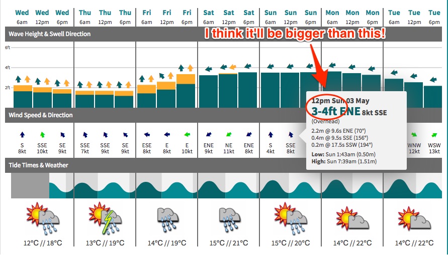
However, model guidance is split as to what will evolve synoptically at the coast. Even though there’s been a minor downgrade in the strength of fetch (now expected to be more E/NE than NE), its slow moving, sustained nature should still result in a peak somewhere around 4-6ft at open beaches on Sunday (a little smaller Saturday as the swell builds), with bigger waves on the South Coast.
Yes, this is bigger than what our automated model is calling right now but I have a feeling it's not capturing the fetch very well at the present time.
What is less likely now is the onset of a freshening westerly wind as the trough disipates and moves eastwards. The Long Wave Trough approaching the continent from the south-west has also been stalled, and as a result we’re looking at a lingering troughy pattern across the southern NSW coast - so Saturday’s moderate to fresh onshore winds are likely to tend variable into Sunday. This means conditions should improve but may still remain lumpy on the surface.
Anyway, there’s still room for movement over the coming days - by Friday we’ll have a much firmer grip on what’s likely to unfold for the weekend. Either way there won’t be any shortage of swell.
Next week (May 4 onwards)
Sunday’s peak in E/NE swell should hold into Monday morning but will ease throughout the day. Fortunately, a broad fetch trailing out into the South Pacific will ensure plenty of residual E/NE swell for much of next week, albeit smaller in size.
In fact, as was suggested in Monday’s notes, we’re looking at restrengthening of the trades (E/SE of New Caledonia) around Tuesday that - despite not being well aimed inside out swell window - should create a bigger pulse of E/NE swell later next week (late Thursday, Friday and into Saturday). This could generate anywhere between 3ft and 5ft of quality E/NE swell for most open beaches. However we’ll have to wait to see how the update model data presents this scenario.
Otherwise, the passage of the LWT over south-eastern Australia will create several southerly swell events. The first is due around Wednesday, extending from a front exiting eastern Bass Strait on Tuesday, however a more long-lived series of swells are expected later in the week as broader fronts push south of Tasmania.
Either way next week has a wide range of swells on tap so there should be no shortage of surf to pick and choose from. See you Friday!
Comments
hi we are planning on going to cloudbreak next thursday till sunday but can pull the pin on it if the surf is going to be really good here and not so good there. i am happy with ene swell here with offshore winds but sth swell not to worried. i just dont want to go there if its going to be really good here. can you give me any guidance mate it would be appreciated
Sorry mate, I missed this. I'll have a look later today when I get a moment.
hi mate looks like 3 ft 20 sec period swell and 18 sec 3 to 4 ft second ay what does that period mean does that mean it will feel a lot bigger with those periods and its the right swell direction sw
thats cloudbreak i am talking about with long periods like that what am i to expect at 18 to 20 sec periods 2 to 4ft range or 2 to 3
Don't know why the BOM have a Dangerous Surf Warning out for today (it was all over the radio/TV yesterday too).
Sunday morning looking good, don't know bout those SW'erlys, predicting onshore east wind swell. And when you say bumpy, do you mean choss or slight woble? cheers
I'll have more details this afternoon Jack. It's been two days since these notes were published, and things have shifted around since then. But winds should be SW.
Cheers mate