Plenty of waves, but dodgy winds

Sydney, Hunter and Illawarra Surf Forecast by Ben Matson (issued Monday 29th December)
Best Days: Tues: fun small E/NE swell - aim for a surf from mid-late morning onwards as winds should become light by then. Wed: good south swell, but probably spoiled by local winds. Thurs/Fri/Sat/Sun: building NE windswell, but probably spoiled by local winds. Sat PM/Sun: good, but inconsistent S'ly groundswell at south facing beaches. Next week: lots of options on the table.
Recap: Easing S’ly swell Saturday with light to moderate onshore winds (stronger in the Hunter, and briefly SW in a few areas). Small residual swells on Sunday, that are looking quite tasty this morning (1-2ft) with early light offshores and a smattering of OK banks about the open beaches.
This week (Dec 30 - Jan 2)
*forecast notes will be brief this week*
Couple of options on the cards this week. The existing small E/NE swell should continue through Tuesday although may wind back just a notch, not so much in size but in consistency. A freshening NE airstream this afternoon will also whip up a small NE windswell into the mix (no bigger than the pre-existing E/NE swell though). So expect slow waves in the 1-2ft range.
A weak cold front will clip the coast before dawn, but has been downgraded since Friday’s forecast and is now expected to have limited influence on the coastal margin during daylight hours - winds will probably become light and variable by mid-late morning (if not earlier), and afternoon sea breezes will probably be weak.
Although a small increase in southerly swell will probably arrive during the afternoon (originating from a gale force W’ly airstream existing eastern Bass Strait) it’s not worth getting too excited about, again probably no bigger than the pre-existing swells.
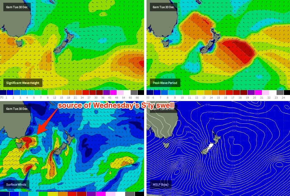
However, Tuesday’s change will be associated with a broader LWT passage, in which we'll see a couple of frontal systems track through our south swell window over the coming days. Not all of these will directly generate swell for southern NSW, but we will see an extended activity of swell from this quadrant during the middle of the week (see chart below).
The next pulse - due early Wednesday - looks to be the biggest, with south facing beaches in Sydney likely to see 3ft+ sets throughout the day, bigger near 4ft+ in the Hunter (note: our swell model chart isn't picking this up very well right now but I suspect it'll recalibrate itself correctly over the coming days. In fact, I wouldn't be surprised if Wednesday punches a little higher than these figures).
However, conditions are likely to be average as a ridge builds across the coast in the wake of the (fast moving) change. The models are in disagreement as to how this will play out - as there is a chance for a brief period of lighter winds during the morning - but for the most part expect moderate to fresh E/SE winds.
Freshening NE winds are then expected through Thursday and Friday, which will kick up plenty of small NE swell for exposed NE facing beaches (fluctuating either side of about 2ft), although conditions will be average at these locations due to the local airstream. There’ll be an undercurrent of small S’ly swell in the water too.
This weekend (Jan 3-4)
Plenty of short range NE swell this weekend, albeit with fresh NE winds as a coastal trough lingers across the SE corner of the country. At this stage wave heights should manage somewhere in the 2-3ft range both days. I’ll firm up the specifics on Wednesday.
Also, a deep, slow moving polar low modelled to develop well below Tasmania around Thursday is expected to kick up a decent southerly groundswell for the weekend. Currently expectations are for an arrival on Saturday afternoon (peaking early Sunday) and set waves should come in around the 3ft mark at south facing beaches - although a lot less consistent than the NE windswell.
Next week (Jan 5 onwards)
Three areas to keep an eye on for next week: (1) strong frontal activity in the Southern Ocean below Tasmania over the weekend, leading to a steady supply of small southerly swells, (2) strengthening trades across the southern Coral Sea, building a good trade swell for Northern NSW that should eventually filter southwards (if the trades spread far enough east, and sustain themselves for at least three or four days), and (3) some more dynamic developments off the Southern NSW Coast early next week, as the weekend’s trough pushes into the Tasman Sea, possibly forming a Tasman Low - and consequently a strong short range SE swell for the coast. More on all of this during the week.
Comments
Plenty of size getting into Bondi now. Bummer about the local winds!
"note: our swell model chart isn't picking this up very well right now but I suspect it'll recalibrate itself correctly over the coming days. In fact, I wouldn't be surprised if Wednesday punches a little higher than these figures."
Got there in the end! (the model's automatic recalibration, that is)