Easing swell all week ahead of a large south swell from Friday

Sydney, Hunter and Illawarra Surf Forecast by Ben Matson (issued Monday 14th June)
Best Days: Tues: easing S'ly swell with generally light variable winds. Fri/Sat/Sun/Mon: large south swell but very windy at times.
Recap: Not a bad weekend of waves. Saturday saw easing south swell from Friday with offshore winds, whilst Sunday delivered a building south swell that was accompanied by fresh W/SW tending S/SW winds from late morning onwards. This south swell reached a peak overnight and was replaced by a new south swell this morning (albeit nearly impossible to detect on the MHL buoy array, due to its similar characteristics to Sunday’s south swell), however was heights are now slowly trending downwards. Early westerly winds swung to the south around lunchtime.
This week (July 15-18)
Not a great deal of activity expected for the next few days. Our current south swell will fade slowly from Tuesday onwards however we’ll see great conditions with generally light variable winds Tuesday freshening from the north-west, then west on Wednesday.
There’s a chance that Tuesday morning may punch a little higher than what our forecast model is currently estimating (2ft south facing beaches) however these bigger waves will be confined to the morning, and will most likely be found in the Hunter (where it’ll probably be closer to 3ft). By Wednesday and Thursday we’ll be back to small residual energy at exposed beaches exclusively, in fact conditions will be quite tiny even at exposed beaches. Offshore winds will become strong and gusty on Thursday as a vigorous front crossed the coast.
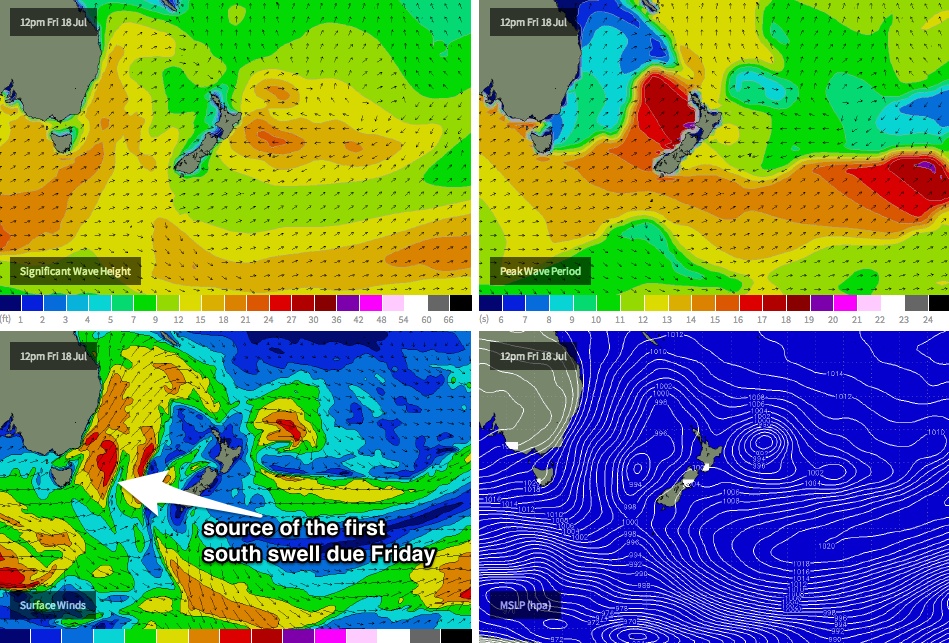
Friday has a strong new south swell on the cards, that’ll be generated in the wake of Thursday’s front (see chart below). In fact, we’re looking at an extended period of strong south swell, all related to an amplification of the Long Wave Trough over New Zealand longitudes from Friday onwards.
Friday will see building energy all day that should push upwards of 6ft+ at south facing beaches by the end of the day (bigger in the Hunter) - however expect much smaller surf in the morning. Unfortunately, early W/SW winds will swing strong to gale force S/SW throughout the day so only protected southern corners will have anything worthwhile as the swell reaches a peak. Let’s take a closer look at the specifics in Wednesday’s update.
This weekend (July 19-20)
The various computer models are all in agreeance about the positioning off the Long Wave Trough across NZ longitudes over the weekend, however they differ in their predictions of where the primary fetch will be steered through the Tasman Sea, and to what strength. This will have a bearing on the eventual size and strength of the surf (as well as surface conditions).
So whilst we should be a little cautious with the numbers at this early time, the overarching weekend theme is for a very large south swell peaking somewhere in the 6-8ft range at south facing beaches (smaller elsewhere, but bigger in the Hunter), with generally fresh to strong S/SW winds, possibly W/SW in a few select areas early mornings. Let’s see how the models are panning out on Wednesday, but right now both days are looking pretty solid indeed.
Long term (July 21 onwards)
As the Long Wave Trough slowly clears to the east early next week, the frontal systems steered along its western flank will slowly push outside of our swell window, leading to a decrease in surf size. However this may not happen until Tuesday or Wednesday (we may see one final system push into our south swell window late Sunday, providing another strong pulse for Monday).
As such, we’re looking at plenty of south swell for the first half of next week, with smaller surf settling in for the back half. Other than that there are no other sources of new swell on the radar for the long term period.
Comments
there seems to be a hint of North in the easterly swell today, (when viewed from South Narrabeen). Almost surfable too, maybe better when the tide goes out a bit more.
Am I just too used to direct southerlies, or is there some source not hinted at in your report?
You're right - there is some tiny short range energy in the mix, which the buoy is showing E'ly thru' E/NE at around 6-7 seconds. It's certainly showing better than what I thought it might.
This energy has most likely originated from the developing northerly airstream well off the coast, which I discounted as a significant swell source when I assessed the charts on Monday - mainly due to the fact that we were coming off an excellent, extended period of good waves and had a large, extended period of south swell due at the end of the week (even now, this morning's ASCAT data - below - doesn't look terribly inspiring).
And when I did the NB surf report this morning it looked pretty small and gutless - it must have improved since then (buoy data certainly support that theory).
I often find this to be one of the hardest parts of the forecasting routine - keeping the forecast notes to 'relevant' weather systems. If I described every single fetch aimed even remotely within the swell window, I'd be here all day listing all kinds of flukey sources that are unlikely to generate anything worthwhile. So this one in particular was deemed to be below the threshold, due to the great waves we had last week and over the weekend, and also due to the upcoming swell.
However had we been in the midst of a lengthy flat spell, it might have been referenced.
Dont take it so hard, just wondering.
Probably not real noticeable most other places. I find across the road here (Sth Narra SLSC) seems to amplify NE swell, so say Mona Vale is 1 ft, here will be 2-3ft (mostly board snapping, close out shorebreaks as I have found out to the detriment of my quiver and bank balance this year)
Ha, got that right about Southey, Queensy was a super fun 2ft+ this morning with what appeared to be a mix of E/SE and E/NE windswell.
Nah, it's all good - every undercall or overcall is a part of the learning cycle. Wish I had more time to spend on forecasting but in reality I get just a couple of hours per day to assess the data and punch out some notes.
don't beat yourself up Ben you're forecasts are generally on point! It is appreciated by all
Always striving for better Mibs! Thanks for the nice words though. Better finish off today's notes then, eh?
I won't lie after I read monday's report i got a little frothy and was hanging for today's update its looking like our local yearly comp will run this weekend.