Extended period of small waves for Southern NSW (plus bonus ice floe discussion!)

Sydney, Hunter and Illawarra Surf Forecast by Ben Matson (issued Monday 12th May)
Best Days: No great days. Maybe a small long period SE swell later Tues and early Wed with light winds (but low confidence for anything worthwhile).
Recap: Plenty of SE swell to kick of the weekend, coming in slightly above forecast expectations for the Saturday dawn patrol (3-4ft Sydney beaches) but easing steadily during the day (down to 2-3ft by late morning, smaller thru’ the afternoon). The Hunter saw slightly bigger waves but it was smaller on the South Coast, and conditions were generally clean with N/NW winds across most beaches. Tiny waves then dominated Sunday with good morning winds ahead of a gusty S’ly change during the middle of the day. This change has whipped up a small, low quality short range south swell for Monday morning.
This week (May 13-16 onwards)
Unfortunately there’s not much to get excited about for the short term forecast period. The small southerly windswell in the water is expected to ease tomorrow, and last week’s suggestion for a stalling trough off the East Coast has somewhat evaporated - the latest model guidance generally has this weak system tracking north-east outside of Sydney’s swell window. One model (ACCESS) still has a small chance for a small peaky E/NE swell during the middle of the week, thanks to the trough/low retrograding slightly back towards the North Coast, but this is an outlier - and even if it did happen we’d only see small surf in southern NSW at best.
As such, the dominant swell event of the week (if you can call it that) is a small long period SE swell due to arrive throughout Tuesday, having been generated within a rare part of our swell window late last week.
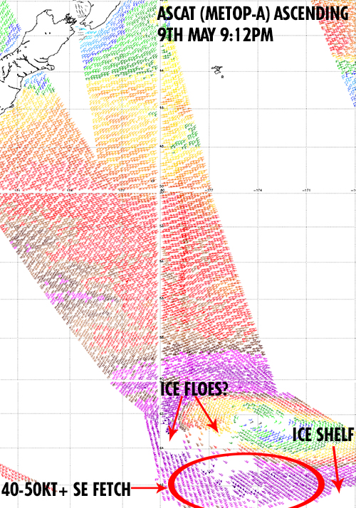
A deep Southern Ocean low formed well to the S/SE of New Zealand on Friday, momentarily stalling and forming a small but intense band of storm force SE winds off the ice shelf, aimed briefly at the Australian East Coast. As I said in last week's notes, the small fetch length, short duration and large travel distance will probably restrict wave heights across the East Coast, so in reality we really can’t expect much more than a couple of feet sometime during Tuesday (probably the afternoon) and maybe early Wednesday.
However, there’s an interesting curveball contained in the image below - this is the ASCAT pass from Friday night, which captured the low and its associated fetch very well.
But if you pay close attention, you’ll notice an area with no wind barbs (white patches) upstream from the SE fetch. This is quite unusual - scatterometry is not affected by cloud cover - and suggests that there may be a broad area of drifting sea ice sitting well north from the Antarctica ice shelf. Although I'm not entirely sure (and drift ice is certainly not an area of my expertise).
The reason this is worth noting is that (with limited analysis time up my sleeve) the storm force SE fetch mentioned above lies across and to the south-east of this possible ‘giant ice floe’, meaning that the resulting swell generated by this SE fetch would probably become heavily attenuated by it (I’m not sure on how much it would influence wave heights, but it’d be reasonable to suspect it’d have a significant negative affect).
I'm unsure whether the wave model has taken this specific area into account or not - I know that sea ice is included in the model's data assimilation but if this was a major swell event I'd probably hone in more specifically to see whether this is indeed a 'giant ice floe' and whether its presence would trigger a recalibration within the wave model.
Anyway, all this means is that an already flukey weather system in a remote, difficult part of our swell window has thrown an even bigger curveballs our way. For what its worth, the models have this swell peaking Wednesday morning with inconsistent sets in the 2ft range. Let’s wait and see what happens!
Otherwise, it’s tiny residual swells expected for the rest of the week.
This weekend (May 17-18)
Tiny residual swells will continue through Saturday, thanks to there being no major swell sources developing later this week.
Sunday has a small pulse of south swell on the cards, generated by a deep low tracking south of Tasmania earlier in the weekend. Current model guidance has this as a reasonably strong system but I’m a little concerned that its forward speed may be too fast to generate any meaningful swell for the East Coast of Australia (as it’ll primarily focused away from us). Let’s have a close look on Wednesday.
Long term (May 19 onwards)
Aside from some south swell originating from the weekend’s low below Tassie, there’s nothing of major interest standing out in the long term at this stage. We’re looking at a prolonged period of small tradeswell for the North Coast (which won’t do much in southern NSW) and otherwise, an amplifying long wave trough over the western half of the country will allow a strong ridge to develop over the eastern states, which will probably deflect a significant percentage of Southern Ocean lows away from our swell window next week. So in short - it could be small for a while. More on this in Wednesday’s notes.
Comments
Hi Ben,
thanks for another in-depth update are we expecting that 2foot swell tomorrow or the barely 1 foot that is showing on the graphs?
The model and graph is not resolving this swell very well. Peak periods might kick up at the buoys early-mid morning (ie 16-17 seconds) but the 'surfable' part of the swell would probably be quite some time behind this (ie late afternoon or early Wednesday). I don't think we'll see much more a couple of feet at exposed swell magnets, and they'll be horribly inconsistent too.
It's not exactly the same situation but I remember having converations with friends about the effect of the Antarctic ice shelf on swell. The shelf moves about 500ks between summer and winter (not sure of exact dist. but could look it up), and that's a lot of fetch. When we get swells formed way to the south (for Victoria) the winter ice shelf would have to lessen the swell size.
In Autumn the storms are there but the ice shelf hasnt formed yet. Which makes another reason it's the best season!
on the upside, at least my arms and shoulders will get a rest
looks like we're gonna get skunked netxt week in Fiji. @#$!ing high setting up in the Tasman for the whole week!
It appears the leading edge of the SE groundswell (originating from the ice shelf) arrived early this morning with peak swell periods around 15 seconds as per the MHL Sydney buoy. And Bondi's showing occasional 2ft sets now.
Actually one set came through a little bigger than that, more like 2-3ft (see below). So this swell has certainly punched a little higher than what was expected. Can't see it lasting through tomorrow though.. will most likely ease overnight.
did u read the news story today on yahoo about the West Antarctic Ice Shelf.?Interesting times. going to be fascinating to see weather patterns, let us ask mother earth and huey that much good swell and favourable wind conditions be one of it's main features.
Hey Ben is the forecast notes for WA this week up on the site yet? I jst can't seem to find them anywhere! Cheers!
Doing them this arvo BL, they'll be up soon (Craig's away).
No worries! Cheers for the head up :)
not very awesome