Average surf tomorrow with building swells from Sunday

Southern Tasmanian forecast by Craig Brokensha (issued Wednesday April 2nd)
Best Days: This evening, Friday afternoon, Saturday, Sunday, Tuesday morning
Features of the Forecast (tl;dr)
- Easing S/SE groundswell tomorrow with W/SW-SW winds, strengthening from the S/SW through the day
- Inconsistent W/SW swell building Fri PM with NW tending varible winds
- Smaller W/SW swell Sat with W/NW winds
- Moderate sized W/SW groundswell Sun AM, a bit bigger into the PM with N/NW tending W/NW winds, strengthening
- Mix of W/SW swell and S/SW windswell Mon with strong SW tending S/SW winds
- Easing surf Tue with W/NW tending SW winds
Recap
Yesterday saw easing levels of mid-period SW swell from 2-3ft across Clifton, while today a new S/SE groundswell has filled in, providing a boost back to 2-3ft under offshore tending variable winds. I unfortunately missed this swell on Monday, too focussed on the Southern Ocean activity but it was another Ross Shelf number, produced by a great fetch of severe-gale S/SE winds on the weekend.
This week and weekend (Apr 3 - 6)
Today’s S/SE groundswell is due to ease back through tomorrow with sets to 2ft+ due to fade through the day and winds look dicey as a trough brings a W/SW-SW breeze.
This will create bumpy conditions that will become choppy after lunch as winds strengthen further from the S/SW.
Friday looks a bit better as a new, inconsistent W/SW groundswell fills in, generated by a strong fetch of W/SW gales on the polar shelf to the south of Western Australia today.
This should build to 2ft through the afternoon with a NW tending variable breeze, while Saturday should see a small increase in W/SW swell from a weakening front moving across us.
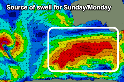
Of greater importance is a strong Southern Ocean frontal progression firing up to the west and south-west of us through later this week, under the influence of a strong node of the Long Wave Trough.
Most of the frontal activity unfortunately looks a bit zonal and north in location resulting in the swell coming from the W/SW, shaving off size, but Sunday morning should come in around 3ft, with building sets to 3-4ft due later in the day, while a trailing front may generate some localised windswell Monday to 4ft.
Local winds on Sunday look best with a N/NW tending W/NW offshore, while strong SW tending S/SW winds are due on Monday as the swell peaks.
The size will back off into Tuesday as winds slowly improve, with some good, long-range groundswell due into the end of the week. More on this Friday.