Generally poor winds this week

Southern Tasmanian Surf Forecast by Craig Brokensha (issued Monday November 20th)
Best Days: Dawn tomorrow morning, Friday morning
Features of the Forecast (tl;dr)
- Small pulses of reinforcing mid-period W/SW-SW swell for tomorrow, Wednesday afternoon, Thursday and Friday
- Early light N/NW winds tomorrow, tending S mid-AM and then strengthening
- Light W-SW-SW tending strong S/SE winds Wed and Thu
- Light N/NE tending strong E/NE winds Fri
- Easing surf Sat with SW tending S/SE winds
- Moderate sized SW groundswell Sun with strong S winds
Recap
The weekend started small with light winds and peaky surf Saturday morning, while our large S/SW groundswell with light winds came in strongly yesterday, with select deepwater reefs providing some of the best conditions seen.
This morning the swell was easing though still solid across the beaches with early light winds and 3ft sets.
This week and weekend (Nov 21 - 26)
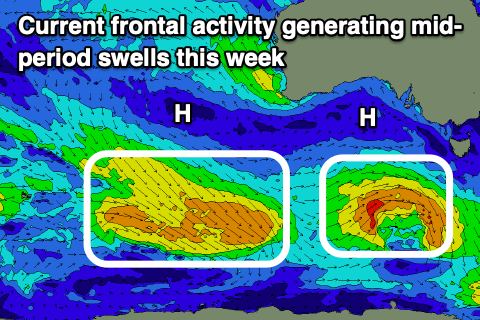
Looking at the week ahead, we’ve got plenty of fun little swell pulses on the way, generated by persistent polar frontal activity sliding in and under the country behind the ‘bombing’ low linked to yesterday’s swell. The only issue are the local winds.
A trailing fetch of W/NW winds behind last week's low should produce fun 2ft+ waves tomorrow, while a secondary relatively weak low that’s south of the Bight today (generating a fetch of strong W/SW winds), should produce a small pulse of mid-period W/SW-SW swell for Wednesday afternoon and Thursday.
This again looks to be in the 2ft range, while a final front behind this should maintain 2ft surf into Friday, easing Saturday.
Local winds are tricky with troughy weather in the region, with a dawn offshore tomorrow due to shift S’ly mid-morning and then S/SE ahead of a stronger change into the afternoon.
This unfortunately looks to leave lingering W/SW-SW winds on Wednesday morning, shifting S/SE through the day while strengthening.
Thursday looks to play out similar wind wise with Friday coming in cleaner with N/NE tending stronger E/NE winds.
Moving into the weekend and the easing swell through Saturday looks to again be met by early SW winds, shifting S/SE through the day and strengthening, while strong S’ly winds on Sunday will spoil a strong new SW groundswell.
The source of this swell is a stronger polar low forming south-west of the state later week, with a fetch of severe-gale to storm-force W/NW winds due to generate a good 4ft of groundswell. There’ll be nowhere to surf though with the poor, onshore winds.
So all in all the coming week looks dicey, and this trend will continue next week as winds shift more SE. More on this Wednesday.