Small swells for the weekend, more action next week

Southern Tasmania Surf Forecast by Craig Brokensha (issued Friday 17th September)
Best Days: Saturday, Sunday, Monday morning, Tuesday afternoon, Wednesday, Thursday, Friday morning
Features of the Forecast (tl;dr)
- Inconsistent W/SW groundswell tomorrow with fresh N/NE tending NW winds
- W/SW swell Sun with strong N tending N/NW, then NW winds
- Building W/SW swell Mon with strong NW tendng W/SW winds, easing Tue with W/SW tending W/NW winds
- Good SW groundswell Thu with N/NW winds
Recap
The surf held in a bit bigger than expected yesterday with sets to 2ft across Clifton, back to a tiny 1-1.5ft today.
This weekend and next week (Sep 18 - 24)
Small surf should continue tomorrow as an inconsistent W/SW groundswell fills in, generated in our far swell window last Sunday and Monday. Inconsistent 1-2ft sets are due along with fresh N/NE tending NW breeze.
Moving into Sunday, and a tricky mid-latitude low that was forecast to drift south-east across us, generating strong W/NW-W winds in our western swell window is now looking more favourable for swell production.
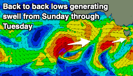 A fetch of W/SW gales will be generated in our swell window tomorrow, producing a fun 1-2ft wave on Sunday with strong N tending N/NW and then NW winds.
Behind this first low, a secondary strong low will fire up, projecting severe-gale W/SW winds through the edge of of our western swell window before pushing a bit too far north and towards South Australia.
As it moves further east it'll weaken and we'll see a fetch of strong S/SW winds drawn up behind it Monday afternoon and evening, bringing some additional S/SW windswell to the W/SW groundswell that's due Monday afternoon and Tuesday morning.
Size wise, we should see Clifton building late Monday to 2-3ft, easing from 2-3ft Tuesday but with strong NW tending W/SW winds Monday, W/SW tending NW on Tuesday.
Wednesday morning should still be around 2ft or so with a NW offshore.
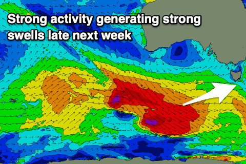 Moving into the end of the week and we've got a strong polar frontal progression and good, long-period SW groundswell pulses due Thursday/Friday.
Back to back fetches of gale to severe-gale W/NW winds should generate the swells, building late Wednesday but likely peaking Thursday to 4ft or so, easing slowly Friday. Conditions are looking great Thursday with a fresh N/NW tending NW breeze, possibly shifting onshore Friday. More on this Monday though, have a great weekend!
Comments
Hey mate. What time would you expect the wind to go from NNE to NW tomorrow?
Around 8-8:30am it looks. So dawn session for the N/NE.
Great. Thanks Craig . Hope you have a good weekend
Cheers, will do!