Good swell to end the week but with less than ideal winds

Southern Tasmania Surf Forecast by Craig Brokensha (issued Wednesday 8th September)
Best Days: Tomorrow, protected spots Friday, Saturday, Tuesday morning
Features of the Forecast (tl;dr)
- Easing SW swell tomorrow AM
- Building W/SW swell late tomorrow with strong NW tending W/NW winds
- Mid-period W/SW-SW swell peaking Fri AM with W/SW winds, tending W-W/NW at times, easing Sat with strong N/NW tending NW winds
- Small-mod sized W/SW groundswell for Mon with strong S winds
Recap
Poor, average start to yesterday with 2-3ft of weak swell and less than ideal winds, but into the afternoon the size kicked strongly with favourable winds for protected spots. A peak was seen overnight with easing, clean 3-4ft waves across Clifton this morning.
This week and weekend (Sep 9 - 12)
The large swell generated by the significant low firing up right off the corner of the state on Monday has now passed and we'll see the swell continuing to ease steadily into tomorrow morning, leaving 2ft waves across Clifton.
 Winds will be offshore but strong from the NW, tending W/NW through the day as a strong frontal progression pushes under us. This will likely bring some late swell with it, but Friday should reveal the peak in mid-period energy.
The frontal progression will generate a great fetch of strong to gale-force W/SW winds through our western and south-western swell windows this evening and tomorrow, with the swell peaking Friday to 4ft across Clifton, easing later in the day, then down from 2ft+ on Saturday.
Conditions look less than ideal on Friday with a morning W/SW breeze, possibly easing and tending more W/NW into the afternoon but likely flirting between W-W/SW.
Saturday looks much better with a strong N/NE breeze, shifting strong NW into the afternoon with a change.
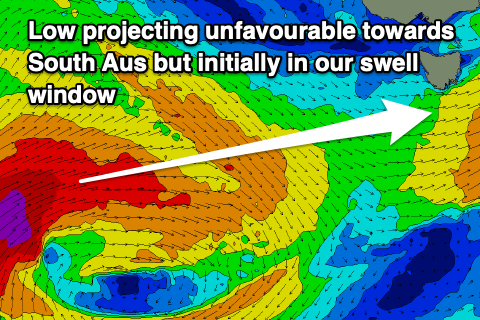 A trough will then bring a strong S/SW change during Sunday which will persist into Monday, spoiling a fun new W/SW groundswell. The polar low linked to this swell will strengthen in our window, south-southwest of Western Australia on Friday, producing severe-gale to storm-force SW winds just within our western swell window before projecting up towards South Australia.
The swell looks to be around 2ft+ but with that onshore wind, conditions will be poor. Winds look to improve Tuesday as the swell eases. Longer term there are a couple of new swell sources for Wednesday and beyond, but more on this Friday.