Fun surf tomorrow across select spots

Southern Tasmania Surf Forecast by Craig Brokensha (issued Wednesday 1st September)
Best Days: Selected locations tomorrow, Friday for the keen, Sunday, next Tuesday and Wednesday
Features of the Forecast (tl;dr)
- Inconsistent W/SW groundswell tomorrow with strong N/NE winds, easing Fri with variable winds
- Inconsistent W/SW groundswell building late Sat with NW tending S/SW winds mid-morning, easing Sun with cleaner conditions
- Large mix of swells on the cards with onshore winds next Tue
Recap
Minuscule waves for beginners yesterday, while today the first signs of new W/SW swell are on the build, clean and to 2ft this morning across the South Arm.
This week and next (Sep 2 - 10)
This morning's increase in swell is mid-period energy from a strong frontal progression that pushed up and under Western Australia earlier this week, with some better groundswell from the strongest part of the fetch due to arrive late today and peak tomorrow morning.
A bit more size is likely later today, with tomorrow coming in at 2ft to possibly 3ft across Clifton.
 Winds will be favourable for selected breaks and strong from the N/NE, while Friday will see early variable winds, giving into a shallow S'ly change mid-morning that may just keep variable winds blowing into the afternoon.
Size wise we'll see the swell easing and dropping from 2ft on the sets (mostly 1-2ft).
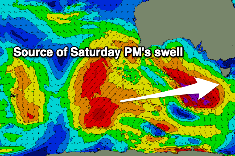
Saturday looks to start tiny, but a new inconsistent W/SW groundswell should be seen into the afternoon, generated by a strong polar frontal progression projecting towards Western Australia today. This will produce a distant fetch of SW gales, before weakening and splitting allowing a weaker polar low to move towards us while generating strong W/SW winds tomorrow evening and Friday.
The groundswell should arrive Saturday afternoon, kicking to 2ft late in the day, with the mid-period energy easing from a similar size Sunday.
 Unfortunately a trough will bring a S/SW change mid-morning Saturday, much better Sunday with a N/NW offshore ahead of SE sea breezes.
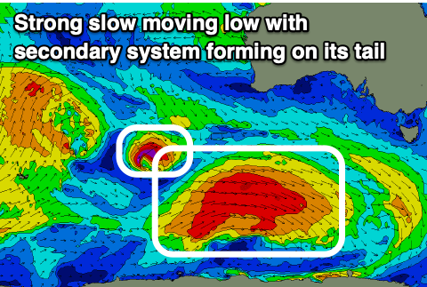
Of greater importance is a strong polar low that's now due to fire up around the Heard Island region tomorrow, pushing east under the country while generating a slow moving fetch of severe-gale W'ly winds. This will generate a moderate to large SW groundswell by itself, but we may see a secondary little low spawning off its tail, pushing up and into us at the same time that the swell arrives, bringing a large, stormy increase in swell next Tuesday. We'll continue to keep a close eye on this and provide an update Friday.