A couple of fun swells with troughy weather

Southern Tasmania Surf Forecast by Craig Brokensha (issued Monday 1st February)
Best Days: Wednesday selected spots, Thursday beginners, Friday and Saturday selected spots
Features of the Forecast (tl;dr)
- Mix of W/SW swells for tomorrow, peaking Wed AM with light E winds
- Good W/SW groundswell for Fri, easing though with strengthening N/NE tending NE winds
Recap
Tiny surf to kick off Saturday with a new swell for the afternoon, better yesterday morning with clean 2ft sets. Today we've fallen in between swells with 1-1.5ft waves and a light offshore wind.
This week and weekend (Feb 2 - 7)
We've got a mix of swells due across the state into tomorrow, the first being a mix of inconsistent, long-period W/SW groundswell and closer-range, mid-period swell. Both were generated by the same polar low that was initially quite strong but then weakened while on approach to us.
On top of this, a cold front that's currently racing in from the west is generating an additional fetch of strong to gale-force W/SW winds, passing under us tomorrow. This should produce an additional W/SW swell for late in the day but more so Wednesday morning.
Size wise, tomorrow morning looks to offer inconsistent 1-2ft sets, kicking to a more consistent 2ft later, easing from 2ft on Wednesday.
 Conditions tomorrow look average as the front brings fresh W/SW-SW winds, tending S/SW later, a touch better though not ideal Wednesday and light from the E, freshening from the E/NE through the day.
Thursday looks cleaner but tiny.
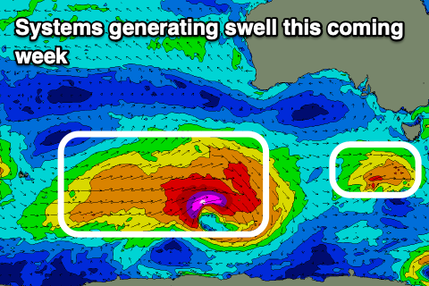
Into the end of the week we've got a stronger W/SW groundswell on the cards, generated by a strong polar low that's currently forming south-west of WA. A great fetch of severe-gale to storm-force W'ly winds will project east before the low weakens south-west of us Wednesday.
The swell is due to arrive late Thursday and peak Friday to a good 2-3ft, easing through the day.
Winds are a touch tricky and will strengthen from the NE on Friday, lighter and more N/NE early, remaining strong from the NE on Saturday as the swell eases from 1-2ft.
Longer term there's further pulses of W/SW groundswell due late in the weekend and early next week though winds look onshore in the wake of a broad low/trough. More on this Wednesday though.