A couple of fun swells, though winds are dicey

Southern Tasmania Surf Forecast by Craig Brokensha (issued Friday 29th January)
Best Days: Early Sunday, Monday morning, possibly Wednesday morning
Features of the Forecast (tl;dr)
- Building W/SW groundswell tomorrow afternoon with a strong S/SW change, easing Sun with early W/NW winds
- Cleaner Mon AM but smaller with a N/NE breeze
- Inconsistent, small W/SW groundswell for Tue but with strong S/SW tending S winds
- Poor S windswell easing Wed with variable breezes
Recap
Onshore surf with 1-2ft of easing S'ly swell yesterday, cleaner in selected spots this morning but tiny and for beginners.
This weekend and next week (Jan 30 – Feb 5)
Tomorrow is expected to start out tiny, but into the afternoon we'll see our new, inconsistent W/SW groundswell filling in. This swell has performed well across Western Australia and we should see it kicking to 2ft+ tomorrow afternoon, easing back Sunday from a similar size.
Unfortunately winds still look average, N/NW tomorrow morning but giving into sea breezes late morning and a stronger S/SW change into the mid-afternoon as a trough moves through.
Winds are now looking better Sunday morning with an early W/NW offshore, shifting W/SW-SW mid-morning ahead of S/SE sea breezes. Come Monday we've got smaller 1-2ft waves due across Clifton with a fresh N/NE tending stronger E/NE breeze.
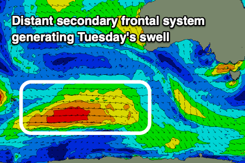 The reinforcing W/SW groundswell for Tuesday is on track, generated by a more distant, slightly smaller polar low firing up behind the storm linked to the weekend's swell. This low is weakening south-west of Western Australia, but will continue to generate strong W/SW winds through our swell window this evening and tomorrow, producing some more consistent mid-period swell.
Unfortunately when this swell fills in Tuesday, with 1-2ft sets due, another trough will bring strong S/SW tending S'ly winds. A closer-range S'ly windswell will develop from these winds, peaking Wednesday morning to 2-3ft or so but with easing onshore winds, possibly going variable at some stage, though we'll review this Monday.
Following this the frontal activity quietens down as cut-off lows form in our vicinity, but we may see an inconsistent new groundswell for next weekend. Check back Monday for more info though. Have a great weekend!
Comments
This run of tiny swell and S/SW winds is hell on earth!
Fingers crossed we bump into something on the near horizon so I don't have to dust off the gym membership!