Fun swells, though onshore when they peak

Southern Tasmania Surf Forecast by Craig Brokensha (issued Wednesday 27th January)
Best Days: Selected spots tomorrow for the keen, Saturday late morning ahead of the change, Monday selected spots
Features of the Forecast (tl;dr)
- Easing S'ly windswell tomorrow with increasing E/NE winds
- Building W/SW groundswell Sat, easing Sun but with onshore winds
- Smaller, cleaner W/SW swell Mon
- Reinforcing W/SW swells next week as winds go onshore
Recap
Nothing of note yesterday and onshore winds with a weak windswell today.
This week and next (Jan 28 – Feb 5)
Any windswell seen today will fade back through tomorrow leaving 1-1.5ft waves for beginners along with an E/NE breeze, freshening through the day. This isn't ideal and will favour selected locations over others.
 Give Friday a miss as the swell will bottom out along with stronger NE winds.
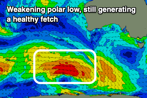
We then look at the inconsistent W/SW groundswell due over the weekend, and the strong polar low linked to this swell is currently weakening south-west of Western Australia. It's been generating a great fetch of severe-gale to storm-force W'ly winds through our far western swell window and will dip east-southeast today while continuing to generate W/NW gales.
The low maintained its strength a little longer than forecast, resulting in a slight bringing forward of the timing of the swell and also a slight increase in size.
We should see the swell building Saturday, reaching 2ft+ across Clifton into the late afternoon/evening, easing slowly from 2ft on Sunday.
A morning N/NW offshore will shift S'th early afternoon with a trough, while Sunday still looks dicey with lingering W/SW breezes ahead of S/SE sea breezes.
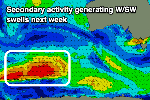 Monday should be clean with a N/NE tending strong NE breeze and smaller 1-2ft waves. The first of a series of reinforcing W/SW swells are due to fill in Tuesday, generated by weaker though persistent polar fronts firing up on the backside of the strong polar low, pushing east and under the country through the weekend and early next week.
Size wise we're looking at pulses in the 2ft range, with the first arriving Tuesday ahead of a secondary swell Wednesday/Thursday.
Winds are tricky and look to shift S/SE on Tuesday as a surface trough deepens to our east, S/SW on Wednesday. Thursday could be cleaner though we'll review this Friday.