Slow week after the recent swells

Southern Tasmania Surf Forecast by Craig Brokensha (issued Monday 25th January)
Best Days: Sunday for the keen, Monday morning
Features of the Forecast (tl;dr)
- S/SW windswell for Wed but with S/SW winds, fading Thu with lingering S/SE winds
- Inconsistent W/SW groundswell building Sat PM, peaking Sun with onshore S winds
Recap
Plenty of swell on the weekend and with favourable winds most of Saturday, giving into sea breezes earlier yesterday afternoon. Today is still fun and clean with easing sets from the 2ft range
This week and weekend (Jan 26 - 31)
After the recent run of good waves, the coming week isn't too crash hot for the region.
We'll see the swell bottom out tomorrow, while a small trough come low pushing in from the west will bring a tricky and not overly favourable swell producing fetch for us.
The low will be unfavourably aligned, with a fetch of strong S/SW winds falling in our swell window on its backside as it pushes east, but this will also see onshore conditions along with the swell on Wednesday. Size wise we're looking at 2ft+ surf across Clifton but with strong S/SW winds.
 Winds look to linger out of the S/SE on Thursday as the windswell fades from 1-1.5ft.
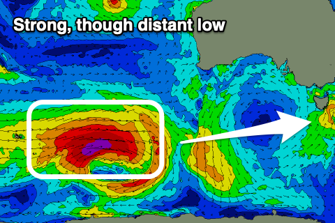
The weekend will start tiny, but later Saturday and more so Saturday, an inconsistent W/SW groundswell is due across Clifton. This will be produced by a strong though distant polar low that's currently firing up around the Heard Island region.
A great fetch of severe-gale to storm-force W'ly winds will be generated in our western swell window, but at a distance, with the end result being an inconsistent groundswell with sets to 2ft from later Saturday through Sunday, easing later.
Conditions will be favourable Saturday ahead of a late S'ly change, spoiling the new swell, lingering from the S/SE on Sunday.
Longer term, persistent polar fronts should generate plenty more surf through next week, though winds look to be an issue and out of the S'th as a strong high sits just to our west. More on this in Wednesday and Friday's updates though.