Significant, upgraded swell

Southern Tasmania Surf Forecast by Craig Brokensha (issued Monday 18th January)
Best Days: Protected spots tomorrow, Wednesday morning, Saturday morning, Sunday morning
Features of the Forecast (tl;dr)
- Large, powerful S/SW groundswell for tomorrow AM, easing with strong, abating SW winds
- S/SE groundswell for Wed, easing through the day
- Fun SW swell for Sat with morning offshores
Recap
Tiny waves Saturday, while a new swell filled in Sunday but with onshore winds. Today is cleaner though and a good size, but a 'bombing low' directly under us will bring a significant, late pulse of SW swell.
This weekend and next week (Jan 19 - 24)

Upgrade!
The strongest and final storm falling under the spell of the Long Wave Trough has been upgraded in strength and intensity, with it now falling into the classification of a 'bombing low'. This is due to the low dropping over 24hPa of central pressure in 24 hours, and it is doing so right now south of us.
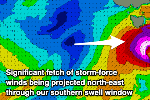 We're seeing a significant fetch of severe-gale to storm-force SW tending S/SW winds projected north-east, through our southern swell window, resulting in a large, powerful S/SW groundswell that's due to peak tomorrow morning.
Seeing this system in winter would be impressive, but in summer and with such strength is quite something.
Size wise it looks like we'll see easy 6-8ft sets across Clifton and plenty of other options with strong but abating SW winds.
With the consistency, power and size this will only be suited to experienced boardriders.
The low will move out of our swell window quickly tomorrow, and this will see the swell dropping rapidly through the day, with Wednesday seeing easing 3ft to possibly 4ft sets, though we'll have a new S/SE groundswell in the water. The S/SE groundswell is also being generated today by a polar low positioned south-southeast of us, generating a good fetch of S'ly gales which would otherwise be a great swell source by itself.
This should produce fun, similar sized 3ft+ waves, easing through the day and with a morning W/NW breeze ahead of S/SE sea breezes.
Come Friday there isn't expected to be much left, with a new SW groundswell due into Saturday. The source of this swell will be a polar low forming south-west of us Thursday evening, generating a good fetch of W/SW gales through our swell window.
Clifton should kick to 3ft+ during the day Saturday and winds look favourable, N/NW ahead of sea breezes, clean again Sunday but easing.
Longer term there's nothing significant on the cards so make the most of the coming swell!
Comments
First pass is in..
been a while since we've seen the purple.