Small to tiny surf continues

Southern Tasmania Surf Forecast by Craig Brokensha (issued Wednesday 30th December)
Best Days: Selected spots Saturday for the keen, Sunday afternoon, dawn Monday
Features of the Forecast (tl;dr)
- Small W/SW swell for Thu PM and Fri AM but with onshore winds
- Tiny surf for the weekend, ideal for beginners
- New swell later Sun, easing Mon with workable winds
- Possible stronger swell late week (though with SE winds)
Recap
Easing surf from Monday, back to a fun 1-1.5ft for beginners and groms yesterday morning, tiny today.
This week and weekend (Dec 31 – Jan 3)
The period will continue to see persistent though not overly sizey pulses of W/SW swell from weak polar fronts moving through our swell window.
Tomorrow is due to start tiny, though a small pulse of W/SW swell is expected into the afternoon, easing Friday, generated by a weak frontal system the last couple of days. Sets to 1-2ft are due at the peak of the swell, though a trough moving through this afternoon will leave S/SE winds into tomorrow, E/NE on Friday and freshening through the day.
 Into the weekend, a tiny SW swell may be seen Saturday from pre-frontal W/NW winds moving through our swell window this evening and tomorrow. 1-1.5ft sets should show and N/NE tending NE winds will favour selected breaks.
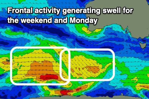
A better, though inconsistent W/SW mid-period swell is due to build Sunday afternoon, peak overnight and ease Monday. The source is a polar frontal progression that developed around the Heard Island region yesterday evening. A broad fetch of strong to sub-gale-force W/SW winds are being projected west, with the swell due to kick to 2ft late Sunday, easing from 2ft on the sets Monday.
Sunday will see N/NE winds again through the morning ahead of S/SE sea breezes (though with no major strength), variable Monday morning ahead of a trough and S'ly change.
Secondary, persistent polar frontal activity through our swell window should keep Clifton topped up around 1-2ft Tuesday and Wednesday, while a stronger polar low may generate a stronger swell late week. Winds could still be an issue and SE though, but more on this Friday.