Small to tiny swells persist

Southern Tasmania Surf Forecast by Craig Brokensha (issued Monday 28th December)
Best Days: Tomorrow morning, beginners Wednesday morning, Friday morning selected spots, Sunday morning
Features of the Forecast (tl;dr)
- Small to tiny W/SW swells this week, best tomorrow AM, spoilt by onshore winds late week
- Small, inconsistent W/SW groundswell early next week
Recap
Fun waves Saturday, tiny and ideal for beginners yesterday. Today the swell remains tiny but we should see a small kick in size this afternoon from the W/SW. The forecast kick to 2ft+ now looks unlikely, with the stronger core winds that were forecast within the swell generating front yesterday, not coming to fruition. Instead weak 1-2ft waves are likely.
This weekend and next week (Dec 29 – Jan 3)
With the lack of any real size this afternoon from a weak cold front that moved in from the west yesterday, we'll see tomorrow's easing trend accelerated with fading 1ft to possibly 2ft sets across Clifton. Wednesday then looks tiny, though a weak front pushing in from the west today and tomorrow should produce some new small, mid-period W/SW swell for Thursday, easing Friday.
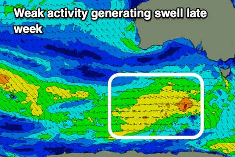 The fetch strength won't be overly impressive but we should see building sets to 1-2ft across Clifton through the day Thursday, easing from 1-2ft Friday.
Coming back to the local winds over the coming days and tomorrow morning will be great with a light to moderate N/NW'ly ahead of afternoon sea breezes, lighter N/NW Wednesday morning with stronger sea breezes.
Unfortunately out onshore S/SE winds for Thursday are still on the cards as a surface trough sits just to our north-east. We should see lighter E/NE winds Friday morning, increasing through he day as the small W/SW swell eases.
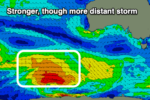 Longer term we'll still receive small, inconsistent levels of W/SW swell from not overly strong frontal activity through our medium-range swell window.
The best such system is forecast to develop around the Heard Island region tomorrow, generating a fetch of polar W'ly winds and inconsistent W/SW groundswell for later Sunday but more so Monday. Size wise it looks to be only 2ft or so on the sets again and winds look dicey with a trough bringing an onshore change Sunday afternoon that may linger into Monday. More on this in Wednesday's notes though.