Continuation of small westerly swells

Southern Tasmania Surf Forecast by Craig Brokensha (issued Friday 25th December)
Best Days: Tomorrow, Sunday for beginners, Monday, Tuesday, Wednesday morning for beginners
Features of the Forecast (tl;dr)
- Easing mid-period SW swell tomorrow with morning offshore winds
- Small W/SW swell pulses next week (strongest Mon PM), becoming onshore Thu/Fri
Recap
A kick in swell through yesterday though not the cleanest, better than expected this morning and clean with the SW component of the new swell offering fun 2ft sets.
This weekend and next week (Dec 26 – Jan 1)
Our fun, mid-period swell event is providing good 2ft sets today and we should see similar sized waves tomorrow morning ahead of an easing trend into the afternoon, tiny but ideal for beginners Sunday.
The westerly stormy track will remain active though weak through the coming period and this will continue to produce small pulses of W/SW swell for Clifton next week.
It won't be overly strong swell, with the best pulse at this stage due to fill in Monday afternoon.
Coming back to the local winds on the weekend though and a morning N'ly will create clean conditions tomorrow morning, strengthening from the E/NE into the afternoon. Sunday looks to see strong N/NE winds most of the day ahead of a late afternoon S/SW change as a trough moves through.
 This trough will be attached to a strengthening cold front moving in from the west but dropping south-east through our swell window.
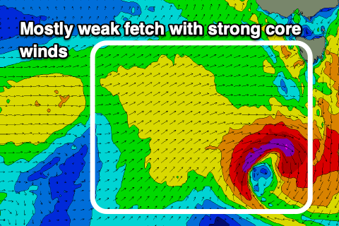
The swell potential from this system has been upgraded a touch, with a fetch of strong W/SW winds being temporarily generated through our swell window, with a very tight core fetch of stronger severe-gales forecast. This should produce a kick in size Monday afternoon to 2ft+, easing Tuesday from 2ft.
Winds on Monday should be offshore and W/NW, swinging SW into the afternoon but without too much strength, while Tuesday looks fun as well with a N/NW offshore ahead of S/SE sea breezes.
Into the rest of the week, continued frontal activity through our swell window should produce some better swell late week, but a deepening inland trough will squeeze a high to our west, bringing E/SE winds. More on this Monday, Merry Christmas!