Good run and mix of swells

Southern Tasmania Surf Forecast by Craig Brokensha (issued Monday 28th September)
Best Days: Tomorrow, Wednesday, Thursday, Friday, Saturday morning, Sunday morning (basically every day)
Recap
Tiny, onshore surf Saturday with a building windswell later in the day, followed by some better mid-period energy yesterday but with persistent onshore winds.
Today conditions improved with a reinforcing pulse of S/SW swell, keeping Clifton up around 3-4ft.
This week and weekend (Sep 29 – Oct 4)
The polar front generating today's reinforcing swell left our swell window yesterday and we'll see the size ease back from 2-3ft tomorrow morning with cleaner conditions under a N'ly offshore, shifting stronger E/NE into the afternoon.
Later in the day but more so Wednesday, our strong pulse of S/SE-SE groundswell is due, produced today by a strong and stalling low under New Zealand.
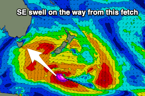 A broad fetch of gale to severe-gale S-S/SE winds have been aimed through our swell window and the low is now aiming the bulk of its fetch further east, into New Zealand and the Pacific Ocean.
The groundswell should fill in Wednesday and provide inconsistent 3ft+ sets across Clifton, easing from 2ft+ on Thursday morning.
More exposed breaks to the south-east energy will be larger though winds from the N/NE tending N will limit surfing options.
Thursday looks a bit better across these exposed breaks as winds shift to the W/NW.
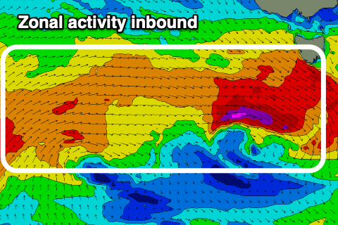 As the surf eases out of the SE we'll see some new W'ly energy building across the state as a series of strong mid-latitude fronts push in, dipping east-southeast through our swell window.
This isn't ideal for generating any major size but the back to back nature of each front should help produce fun pulses of swell, likely peaking around 2-3ft from Friday afternoon through Sunday. Thursday may see a small 1-2ft wave, but the SE energy will be better.
Winds under this regime will be favourable and out of the N/NW Friday, similar Saturday morning ahead of a S/SE change and possibly lingering into Sunday but most likely variable.
We'll have a closer look at the winds for the weekend on Wednesday though.