Tons of swell this period

Southern Tasmanian Australia Surf Forecast by Craig Brokensha (issued Friday 11th September)
Best Days: Tomorrow afternoon, Sunday morning, Monday, Tuesday, Wednesday, Thursday
Recap
Tiny surf yesterday and today.
This weekend and next week (Sep 12 - 18)
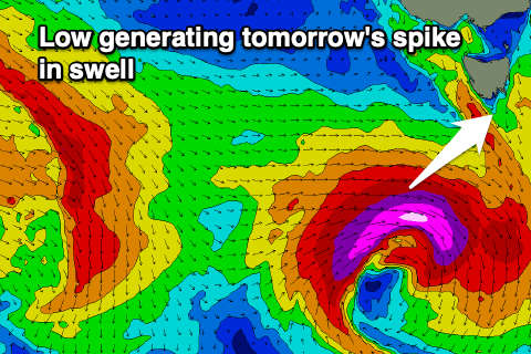
Our spike of new SW groundswell for tomorrow is on track with a deep and powerful low forming west-southwest of us, with it dropping rapidly south-east though while generating a fetch of severe-gale to storm-force W/SW winds.
A strong and solid but short-lived kick in swell is expected from the low tomorrow, swinging in direction from the W/SW to SW though peaking around 3ft+, easing rapidly Sunday from 2ft or so.
 Winds are still an issue at dawn tomorrow and onshore out of the S/SW, though we should see them becoming variable later morning and into the afternoon with the peak in size.
Sunday will be great with N/NW winds persisting all day.
We then look at the progression of frontal systems moving in from the west on the weekend.
We’re looking at a good and drawn out area of gale to severe-gale westerly winds moving through our swell window, then tracking more north-east and towards the Tasman Sea while passing under us early next week.
We’ll see the swell building out of the W/SW on Monday but peaking from the SW Tuesday, then easing Wednesday.
Size wise Clifton looks to build to 3-4ft during Monday afternoon, with Tuesday revealing 4-6ft surf across CLifton, then easing slowly from 4-5ft Wednesday, buoyed on by a final front firing up late in our swell window.
Winds should be favourable and from the NW tending W/NW on Monday, then better for protected spots Tuesday and W/SW. Wednesday looks great for exposed breaks as winds shift back to the N’th and then tend variable NW.
We’ll confirm this on Monday though. Longer term there’s nothing too significant but more on this Monday. Have a great weekend!