Tiny west swells until next week

Southern Tasmania Surf Forecast by Craig Brokensha (issued Wednesday 30th October)
Best Days: Tuesday morning next week, Wednesday
Recap
Plenty of S'ly swell left in the mix yesterday with sets to 2-3ft, still 1-2ft this morning but with dicey winds.
This week and weekend (Oct 31 – Nov 3)
As touched on Monday, in the wake of the current swell easing, the outlook is for tiny waves this coming period until mid-late next week.
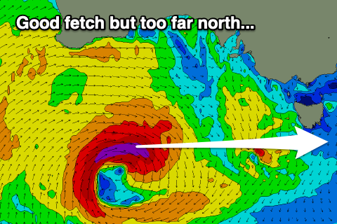
Even with an intensification of the current system developing west-southwest of WA, all the activity will be mainly north of our swell window and as a result we're not expected to see any of the W'ly swell due from Saturday filling in to the South Arm.
 Through Monday we may see a bit more energy wrapping in, as a weak but broad front passes under the state, generating strong W'ly winds.
We may see sets pushing 1-2ft later in the day Monday, but more so Tuesday morning with N/NW tending W winds on the former and better N winds on the later.
Of greater importance is a flurry of stronger storms firing up in our western swell window mid-next week. The track of these look to be on a knifes edge regarding being too north, but hopefully we'll see them south enough to generate a decent pulse of W/SW swell mix-week.
We'll have to look closer at this on Friday when the models come more into alignment.