Make the most of the coming week

Southern Tasmania Surf Forecast by Craig Brokensha (issued Monday 28th January)
Best Days:
Recap
Small clean 1-2ft waves Saturday morning ahead of our new S/SE groundswell into the afternoon, with it easing back from an inconsistent and clean 2-3ft yesterday morning. This morning the swell was all but gone, replaced by a new building W/SW swell.
Today’s Forecaster Notes are brought to you by Rip Curl
This week and weekend (Jan 29 – Feb 3)
Looking at tomorrow's upgraded W/SW groundswell and the storm linked to this is currently just west-southwest of us, generating a great fetch of severe-gale W/NW winds, with a tight tail fetch of storm-force W/SW winds.
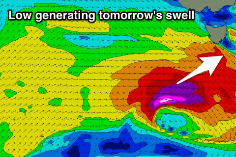 A low pressure centre is developing and we'll see these storm-force winds expand a little in scope as the storm drops east-southeast and then under us this evening and early tomorrow.
A large long-period but very westerly swell should be seen, building through tomorrow to a strong 3ft across Clifton under a N/NW offshore, giving into afternoon sea breezes.
Wednesday looks fun also as the swell eases back from 2ft along with N/NE offshore ahead of sea breezes.
Into Thursday afternoon and Friday morning a small reinforcing mid-period W/SW swell should keep wave heights around 1-1.5ft, generated by a broad fetch of strong W/SW winds on the tail of the strong low.
Winds will unfortunately be onshore Thursday out of the SW with a change, while Friday should offer an early W/NW breeze, tending onshore mid-morning then S/SE into the afternoon.
From here there's nothing too major on the cards for us into next week, so make the most of the coming swells.