Strong swell Sunday, waves most of next week

Southern Tasmania Surf Forecast by Craig Brokensha (issued Friday 9th November)
Best Days: Sunday morning, Monday, Tuesday morning, early Thursday
Recap
A slight drop in size from Wednesday into yesterday with nice clean conditions through the morning, while today we're back to small to tiny conditions though nice and clean again.
Today’s Forecaster Notes are brought to you by Rip Curl
This weekend and next week (Nov 10 - 16)
Tomorrow will be tiny as the surf continues to fade, but our new SW groundswell for Sunday is still on track.
Yesterday a strong polar low formed south-west of WA, with a fetch of severe-gale to storm-force W'ly winds generated in our far western swell window, but this low has since broadened and slowed.
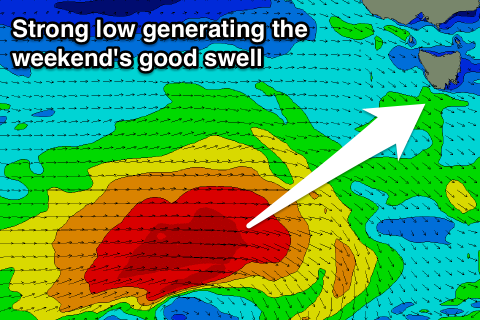 We're now seeing a great fetch of gale to severe-gale W/SW winds generated through our south-western swell window, south of the country.
This low will move slowly east before dipping east-southeast and away from us when approaching closer.
A consistent long-period SW groundswell will be produced, arriving early Sunday morning and peaking through the day to 3ft to occasionally 4ft across Clifton.
Winds will be offshore early from the W/NW, but as the swell peaks we'll likely see onshore W/SW tending SE winds.
The swell will ease through Monday but should still come in at 2-3ft with a great N/NW offshore ahead of E/SE sea breezes.
For the rest of the week we'll likely see small swells pulsing between 1ft to occasionally 2ft, mostly Wednesday afternoon and Thursday morning owing to unfavourably aligned but persistent polar frontal activity through our swell window.
Winds will become an issue as a strong high moves in from the west on Wednesday bringing S'ly breeze, but early W/NW offshores are more than likely.
We'll have a closer look at this on Monday. Have a great weekend!