Fun easing surf tomorrow, new swell later Sunday, easing Monday

Southern Tasmania Surf Forecast by Craig Brokensha (issued Friday 26th February)
Best Days: Saturday, Monday morning, Tuesday morning
Recap
Tiny leftover waves yesterday morning, while today a new mix of short-range and longer-range W/SW groundswell took a while to get going. Early the surf was tiny and weak, but the swell has since filled in much better with 2ft to occasionally 3ft sets across Clifton. Conditions should remain clean all day as well.
This weekend and next week (Feb 27 – Mar 4)
Today's good increase in W/SW swells are due to ease back into tomorrow, and our reinforcing SW swell due for tomorrow has now been downgraded a touch and due to be more from the W/SW.
This is due to the secondary intensification of the frontal progression pushing under us today not being as strong or favourably aligned.
In saying this we should still see 2ft+ sets tomorrow morning, easing into the afternoon and then tiny Sunday morning.
Offshore winds are due most of tomorrow from the W/NW, while Sunday morning will again be clean with a W/NW'ly ahead of a mid-late afternoon S/SW change.
 The onshore change will be linked to a strong polar front moving in from the west, but this system was forecast to be a polar low for most of this week.
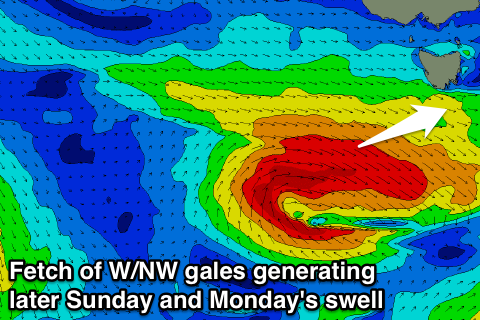
Instead this weaker front will produce a less than ideal fetch of pre-frontal W/NW gales through our western swell window, with a late increase in size due Sunday, peaking Monday morning to 2ft.
On the backside of the low a quick burst of S/SW gales should produce a small S'ly swell later Monday and Tuesday morning once the W/SW swell eases, but only to 1-2ft or so.
After Sunday's onshore change, winds are due to swing quickly around to the N/NE, favouring more exposed beaches.
Longer term there's nothing too significant at all for the South Arm, but check back here on Monday for an update on this. Have a great weekend!