Average weekend, much better mid-late next week

Southern Tasmania Forecast (issued Friday 24th October)
Best Days: Sunday morning exposed coasts, Tuesday morning, Wednesday, Thursday, Friday
Recap
Yesterday was poor with onshore winds and a junky swell, while today was better with 2ft of swell under offshore NW winds before they strengthened from the NE.
This weekend (Oct 25 – 26)
Tomorrow will be poor with an overnight change lingering from the SW during the morning and swinging more S'ly through the day.
This change will be linked to a polar front though and with this we should see a pulse of swell Sunday morning to 2ft on the sets around Clifton. Winds will be better but still average with an early light NE breeze expected to strengthen during the day, favouring more exposed spots.
 Next Monday onwards (Oct 27 onwards)
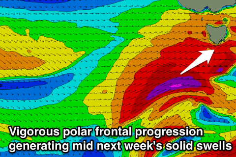
Monday will be tiny, but a deepening mid-latitude front pushing across us should produce a slight pulse of acute W/SW swell for Tuesday morning.
Of greater importance is a follow up frontal system developing further south and more in our swell window, right on the back of the initial front, aiming a fetch of gale to severe-gale W/SW tending SW winds towards us.
This should produce a larger W/SW tending SW swell for Tuesday afternoon and Wednesday, building to 3ft+ later in the day Tuesday and coming in at 4-5ft Wednesday morning.
Winds as the swell kicks Tuesday will be less than ideal and fresh from the W/SW, but Wednesday looks great with NW tending W/NW winds.
From Wednesday afternoon the swell will steadily tail away under favourable winds, creating a good few days of pumping surf. Check back here on Monday for the latest on this though and in the meantime, have a great weekend!