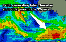
Fun clean S/SE swell Wednesday/Thursday
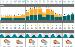
Tiny tomorrow, with a late increase in onshore windswell. New fun S/SE groundswell for Wednesday with offshores, easing Thursday.
Onshore and poor tomorrow, new small S/SE groundswell for Wednesday, and then a better SW swell later Thursday/Friday morning.
I’m expecting Tuesday to push slowly up into the 3ft+ range at south facing beaches south of Byron during the day.
Easing mix of swells tomorrow and Wednesday with SW winds (possibly W'ly early around Victor), then fun SW swell with offshores Thursday, smaller and fading Friday.
We’re at the start of an extended run of S/SE swell originating from a strong frontal progression south of New Zealand from late last week through the weekend, which is expected to reach a peak on Wednesday.
Easing mix of W/SW swells tomorrow, steadying Wednesday with less than ideal winds. Fun swell for Thursday, cleanest on the Surf Coast and then good east of Melbourne from Friday.
Sunday's swell event has eased back a touch with the core fetch of 55kt winds becoming pinched and elongated. Core winds never really reached the 60kt potential, so the swell periods will be lacking for the outer bombies.
Regardless, the surf along the inshore is still more than likely to be very big, with light winds bringing a good chance of good surf. We will be monitoring the situation closely as it unfolds.
The low that generated today’s south swell is already exiting our swell window to the east, so surf size will ease rapidly from this source overnight.
Today’s south swell will be well and truly on the way out by Saturday morning.
Building S'ly swell with average winds tomorrow, easing Sunday with workable winds in protected northern corners. Fun easing N/NE windswell Monday and then an inconsistent S/SE groundswell for Wednesday.