Fun clean S/SE swell Wednesday/Thursday

Eastern Tasmania Forecast by Craig Brokensha (issued Monday 7th September)
Best Days: Wednesday, Thursday morning
Recap
Small levels of S'ly swell to 2ft or so across south facing beaches Saturday and Sunday with clean conditions each morning. A fresher N/NE wind yesterday afternoon brought with it a late increase in N/NE windswell which peaked this morning to 3ft across north-east facing beaches. Conditions were less than favourable though with winds lingering from the N'th all morning.
 This week and weekend (Sep 8 - 13)
The N/NE windswell is due to ease overnight with tiny waves left into tomorrow morning as a S'ly change pushes up the coast.
This is expected to kick up a late increase in S'ly windswell but not above a very weak 2-3ft at south swell magnets on dark.
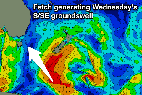
Come Wednesday the windswell should fade away, to be replaced by a new inconsistent S/SE groundswell.
This groundswell has been generated yesterday and today by a broad fetch of gale to severe-gale S'ly winds south of New Zealand. South swell magnets should see inconsistent but good 3ft+ sets for most of the day before easing into Thursday from 2-3ft.
Winds will improve Wednesday and swing light offshore and then variable into the afternoon, with W/NW tending variable winds Thursday.
Come Friday there's isn't expected to be any size left, with the weekend also looking dire besides tiny levels of N/NE windswell.
Longer term some decent S'ly swell may be seen mid-next week, but check back here Wednesday for an update on this.