Easing swell with dicey winds, better from Thursday

 South Australian Forecast (issued Monday 7th September)
Best Days: Early Tuesday around Victor, same Wednesday, Thursday and Friday morning down South, Monday protected spots around Victor
Recap
Really fun waves Saturday with a mix of swells to 3ft at Middleton, bigger out at Waits and Parsons with favourable winds. Sunday was pretty tiny with Waits and Parsons the only option for a wave but with a strong offshore wind.
Today a mix of W/SW swells are pushing in across both coasts, with messy 2-3ft sets on the Mid and more size down South to an east 3ft off Middleton but with a W'ly breeze. We should see more size this afternoon down South but winds have gone onshore. We may see them swing back W'ly on dark, so keep an eye on the coast.
This week (Sep 8 – 11)
This afternoon's mix of building swells are due to ease through tomorrow, but a strong fetch of SW winds projecting into the South Coast this evening will continue to provide plenty of size into tomorrow morning.
The Mid should ease from 2ft+ with the South Coast dropping from 3-4ft at Middleton with 5-6ft sets at Waits under unfavourable SW winds. There's a chance for an early W'ly around Victor Harbor but it will be short-lived.
Wednesday will see the swell easing further and a lingering SW'ly looks to spoil the party again. There may be an early W'ly around Victor, but it won't be worth the drive from Adelaide.
Thursday and Friday morning will be much better as winds swing offshore from the NNE with a new pulse of SW groundswell.
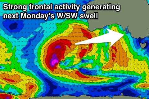
This groundswell is being generated by a gale-force fetch of pre-frontal W/NW winds moving in from the Indian Ocean under the country today.
The Middleton stretch should offer fun but inconsistent 3ft sets with 4-5ft waves at Waits and Parsons through the morning, easing into the afternoon and then becoming small through Friday.
The Mid Coast isn't due to see any major size with tiny 0.5-1ft waves through Thursday, fading Friday.
This weekend onwards (Sep 12 onwards)
Saturday will be clean with fresh to strong N'ly winds, but the swell will be tiny with 1ft+ waves across the Middleton stretch and 2ft+ sets at Waits and Parsons. Sunday will be similarly tiny but with strengthening NW winds, limiting surfing options further.
From next week we should see some better W/SW groundswell energy across the state as a vigorous and broad polar low pushes up and into WA later this week.
This should produce a moderate to large W/SW groundswell, building Sunday afternoon to 1-2ft on the Mid and only 2ft at Middleton late in the day with 3ft sets at Waits ahead of a peak Monday.
The westerly nature will favour the Mid with 2-3ft surf due and size more in the 3-4ft range at Middleton with W'ly winds. This should be followed by some better S/SW groundswell for Wednesday but we'll review this again in the next update.