Fun swell Thursday and then better from Sunday
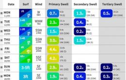
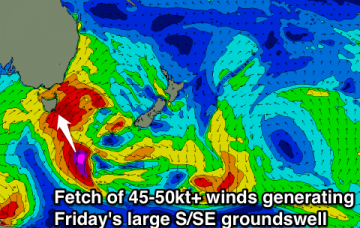
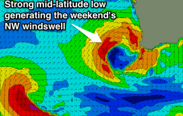
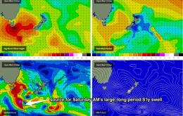
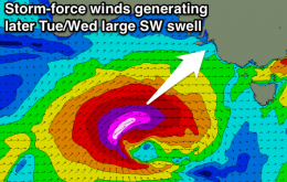
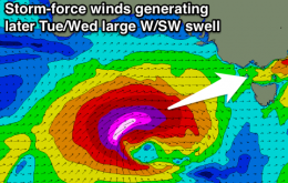
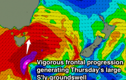
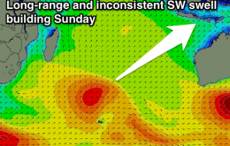
New SW swell for Thursday, easing into the weekend ahead of fun swells from Sunday afternoon with weaker trades.
Several low pressure centres will each contribute strong energy from Thursday afternoon through Friday, and on the whole we’re looking at very large surf in the 6-8ft+ range (Northern NSW south facing beaches) at the height of the swell.
Good S'ly pulse through the day Wednesdaym, larger Thursday and then a better S/SE groundswell Friday, easing Saturday with improving winds.
Acute westerly swell building late tomorrow, peaking Wednesday morning with a mix of new SW swells. SW swell easing Thursday with a large S/SE groundswell Friday. Onshore winds for the most part.
New SW swell building tomorrow with favourable winds, easing through the rest of the week with winds swinging more towards the north. NW windswell for the weekend but with average winds.
Right now there’s an impressive W/SW thru SW fetch of gales existing eastern Bass Strait, courtesy of a vigorous front that crossed the region overnight.
Large building SW swell tomorrow afternoon, easing Wednesday with more south in it. Onshore winds until the weekend.
Large and powerful W/SW swell building tomorrow afternoon, peaking overnight and easing Wednesday. Winds generally onshore besides short periods of W'ly breezes around Torquay each morning from Wednesday.
All in all - a great weekend for most open beaches.
Easing S'ly swell tomorrow, flat until some larger S'ly swell energy from Wednesday, persisting into Friday.