Very large swell but with average winds

Victoria Forecast by Craig Brokensha (issued Monday 11th May)
Best Days: Tuesday until early afternoon Surf Coast, early Wednesday and Thursday for experienced surfers around Torquay, early Friday around Torquay, Saturday and Sunday Surf Coast
Recap
Non-stop pumping waves across the Surf Coast over the weekend with clean 3-5ft surf Saturday morning, pulsing through the afternoon under all day offshore NW winds. The swell held in at 4-6ft Sunday morning under early W/NW winds, before flirting between the W/SW and W through the rest of the day as the swell kicked again late.
This morning the Surf Coast was holding around the 4-6ft range but a little wind affected with a W'ly breeze. This has since shifted onshore from the W/SW creating average conditions. The Mornington Peninsula over the last few days has been big and onshore, with Western Port fairing the best.
 This week (May 12 - 15)
Today's large spike in W/SW groundswell was generated by a strong front pushing into us last night and this morning, and behind this we should see the swell ease into this afternoon and further into tomorrow morning. Winds may swing back to the W/NW late on the Surf Coast this afternoon with an approaching front so keep an eye on the local wind observations and surfcams.
Of greater importance is the large W/SW groundswell discussed in last Friday's update.
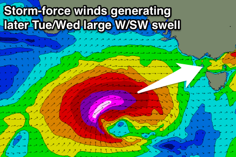
I mentioned that the American model was going ballistic with the strength of this system, while the others were weaker but still significant. Well since then the other models have come more into line with the American model GFS and what we'll see is a large and powerful W/SW groundswell developing through tomorrow afternoon/evening, easing through Wednesday.
This will be a result of an intense low projecting a fetch of severe-gale to storm-force W/SW into us today and tomorrow before pushing across us through the day.
The initial stages of this swell will be shorter-period W/SW swell energy followed by the stronger longer-period energy on dark tomorrow, peaking overnight and easing Wednesday.
The Surf Coast should build from the 4ft range through the morning to an east 6-8ft by late afternoon with bigger 10ft bombs on dark. The Mornington Peninsula should increase from 6ft+ to 10-12ft late in the day but winds will be poor and strong to gale-force from the W/NW tending W/SW through the afternoon.
A peak in size is due overnight ahead of an easing trend from 8ft+ early Wednesday on the Surf Coast and 10-12ft+ on the Mornington Peninsula with strong SW winds. An early W'ly is likely around Torquay creating tricky conditions with the large swell on the reefs.
A couple of secondary fetches of SW gales pushing up and into us through tomorrow and Wednesday should keep large levels of SW swell hitting both coasts into Thursday, easing from the 6ft range on the Surf Coast and 8ft range on the Mornington Peninsula.
Conditions will remain less than ideal though with fresh SW winds across all locations apart from an early W'ly around Torquay. Friday should see the swell easing back from 3-5ft and 6ft+ respectively as SW winds continue (early W'ly around Torquay).
This weekend onwards (May 16 onwards)
The outlook from this weekend into next week isn't anywhere near as active as the current period but fun SW groundswells are on the cards along with improving winds initially for the Surf Coast and then Mornington Peninsula from early next week.
We'll have a closer look at this Wednesday.
Comments
Satellite observations from the low are coming through and its a beast!
60kt core winds speeds (purple triangle barb with large dash)..
Hey Craig,
The initial call on this swell was for quite a bit of South in the direction. Has this moved around to the west a bit more or am I miss-reading that?
Cheers,
Will86, last update I didn't mention direction but it's always been W/SW. On the backside of the swell it'll tend a little more SW in direction Wednesday morning, but that's about it.
Data is a little sketchy but a Max Wave Height of 16m has been measured at Cape Sorell..
Point Nepean is climbing strongly as well.
#itson Wednesday morning surely there will be a window!
Pines here we come!
The 30 ft of Sig height is impressive at 16 sec's for an hideously strong onshore swell .
Be a special journey on the SOT this arvo / tonight ...
Mick i'll give you the tip , swell like this doesn't get formed from fronts that have little sth in the wind following ..... Every wind forecast i've seen and there has been literally hundreds of wind warnings has it SSW by midnight ...... but you maybe lucky and it might not be a total " white out " . Either way it'll be cold , with snow forecast down to 500M tonight / tomorrow morning ....
I think there'll still be an early W'ly (W/SW at worst) around Torquay at dawn, but she'll be raw, unruly and victory at sea conditions.
#itsoff no window tata. I did my back in at Winki anyway. Did you get any Southey over the last few days?
and Craig was right West in the wind right now, but doesnt look like it helped
Some of the biggest data recorded at Cape Sorell (and Cape du Couedic) overnight. Imagine doing the crossing on the Spirit of Tasmania?
new lines starting to front at Weerie