Southerly swell to dominate, large late week

Eastern Tasmania Forecast by Craig Brokensha (issued Monday 11th May)
Best Days: Wednesday midday, Thursday protected spots, Friday protected spots, Saturday south swell magnets
Recap
Easing Sly groundswell from Friday's good pulse with offshore winds, while Sunday and today were clean but tiny with the swell being too west to get in.
 This week and weekend (May 12 - 17)
A small pulse of S'ly swell to 2ft or so across south swell magnets may bee seen tomorrow but conditions will be tricky and windy with a strong to gale-force W/NW breeze.
There'll be better swell into the middle to end of the week in any case to make the most of.
Firstly a very strong and powerful low pressure system pushing across us Tuesday night is expected to aim a fetch of severe-gale to S/SW tending SW winds through our southern swell window.
This should produce a short-lived pulse of S'ly groundswell during the day Wednesday that isn't due to be there at dawn but should be in by mid-late morning.
South facing beaches should pulse to 3-5ft through the day before easing at some stage through the afternoon. Winds will be OK but not great with a fresh to strong W/SW tending W'ly breeze through the day before swinging back to the W/SW late afternoon.
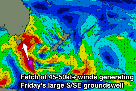
Some better and large groundswell energy is due into Thursday and Friday though as a secondary vigorous frontal system pushes through Wednesday afternoon, projecting a fetch of severe-gale S/SW winds up through our southern swell window.
Then below this towards the polar shelf a fetch of severe-gale to storm-force S'ly winds will be projected northwards.
Two separate pulses of S'ly and then S/SE groundswell will be generated, the first for Thursday coming in at 6-8ft across south facing beaches, with 3-5ft sets at open beaches.
The secondary S/SE groundswell should then peak Friday morning 4-5ft+ across open beaches and 6-8ft+ across south facing locations.
Winds will be an issue though with strong to gale-force but easing S/SW winds Thursday and then SW winds Friday.
Come Saturday conditions should be excellent across south facing beaches with a W/NW offshore and easing S/SE groundswell from 4-5ft.
From there on the swell will continue to drop out of the S/SE Sunday with nothing major on the cards at all into early next week. We'll have a closer look at this on Wednesday though.