Pick the winds and swell pulses this period
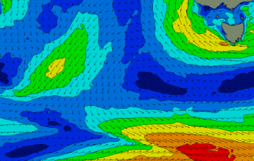
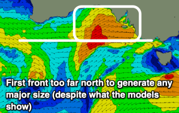
A mixed period with today and later next week providing the most reliable swell. In between we're looking at a flukey period early next week.
Still on track for some large, windy surf for the NE coast as an approaching low pressure system focusses an infeed of E’ly winds onto the coast and an associated NE fetch in the Tasman, adjacent to the NSW coast sends NE swell towards Tasmania.
Weekend is still looking good, with NE/ENE swell being generated by the slow moving fetch feeding into the trough, extending out towards New Caledonia and a basically W’ly wind pattern.
The fetch remains active over the weekend, although slightly weaker compared to earlier model runs. Compensating for lower windspeeds will be a broad coverage of wind from the Northern Tasman, up into the Southern Coral Sea.
There's been a slight improvement to one day this period but otherwise a slow moving low will bring onshore, poor conditions.
The rain has already started to hit and we'll see winds winds coming over the next few days along with building surf.
Make the most of this morning's clean conditions down South as we'll see poor conditions from this afternoon. There'll be plenty of size but by the time conditions clean up again the surf will be small.
There's plenty of swell from multiple directions to end off the week, but we'll see conditions slowly improve with varying winds. The weekend should open up more options as the size slowly fades.
Tempestuous, windy week ahead for the region with a dominant high moving NE into the Tasman, generating NE windswell before an inland low approaches and brings strong onshore winds and large seas and swell.
There's plenty of swell on the way for the coming week but a deepening and slow moving mid-latitude low will set up across us, bringing onshore winds.