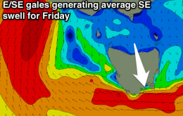
Get in dawn Thursday, onshore there onwards
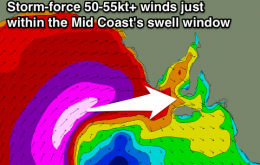
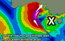
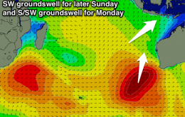
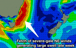
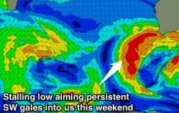
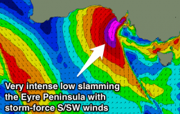
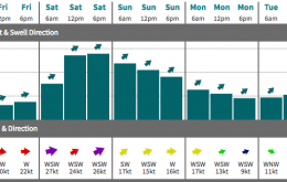
Easing clean swell early tomorrow, onshore from the afternoon through the weekend and most of next week. XL swell building Saturday afternoon, easing Sunday.
Large W/SW groundswell for the Mid tomorrow with improving conditions into the afternoon as onshore SW winds ease. Clean early down South. Stormy waves for both coasts Friday, clean and super fun South Coast Saturday, tiny Sunday. Lots of W/SW swell for next week.
Good W/SW swell for tomorrow morning with northerly winds, easing during the day and then a small acute W'ly swell for Friday with light winds. Average small mix of swells Saturday, cleanest on the Surf Coast, then small and weak Sunday.
New S/SW swell for later Wednesday and Thursday, with another pulse Friday. Strong inconsistent SW swell building Sunday afternoon, with a larger S/SW swell building Monday.
Friday has some good potential for some good NE windswell across most coasts.
Tiny ahead of a large stormy building NE swell Thursday, easing with workable winds Friday, down further Saturday.
Strengthening N/NE winds along the NSW coast on Thursday look like they’ll reach gale force strength by the afternoon, which should produce large surf at NE facing beaches by late in the day, especially south of Wollongong.
No decent swells over the coming period and with funky winds due to an intense low moving in from the west.
Building SW swell tomorrow with onshore winds, easing Wednesday under S/SE breezes, clean early Thursday and smaller again. Large stormy mix of swells developing into the weekend.
Mix of W/SW and building SW swell tomorrow with good winds for the South Coast. Building W/SW swell for Wednesday with deteriorating conditions down South, cleaning up on the Mid and then a tricky mix of swells to end the week with a very intense low.