Tricky forecast for Thursday as severe low moves east

South Australian Forecast by Craig Brokensha (issued Wednesday 28th September)
Best Days: Mid Coast Thursday afternoon, South Coast keen surfers Thursday morning, South Coast Saturday, protected spots South Coast next weel
Recap
Clean fun waves across the South Coast yesterday, better through the day as winds tended more offshore. A new swell also provided more power and size into the afternoon. The Mid Coast was a bumpy and less than ideal 1-2ft.
Today, the weather and surf started fine with clean good waves across exposed spots down South and 1-1.5ft surf on the Mid. A strong pre-frontal storm has just swept in from the north-west though bringing torrential rain, while the swell has also kicked on the Mid with clean 1-2ft sets.
This week and weekend (Sep 29 – Oct 2)
Today's incoming storms are just a taste of what is to come over the next 48 hours.
 A severe and deep low pressure system has formed in the Bight and this will project storm-force SW-S/SW winds straight up into the Eyre Peninsula this afternoon and evening.
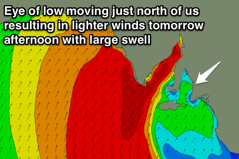
The models have been struggling with how north the eye of the low will track, and this is quite important regarding how much swell the Mid Coast will get as well as what winds to expect.
At the moment it's touch and go, but the centre looks to be just south enough to generate large amounts of W/SW groundswell for tomorrow, mixed in with smaller amounts of windswell. This will be a result of the low centre almost moving over us, with gusty NW winds, due to swing SW and ease right off into the mid-late afternoon.
With this conditions should improve considerably into the afternoon and the swell is expected to come in at a strong 3-4ft.
The South Coast isn't likely to see much size at all with the fetch of winds being too north and west to generate any major swell at all. Instead a new W/SW groundswell should provide fun 3ft sets across Middleton under that fresh morning NW wind.
Later in the day we may see some new S/SW swell filling in but conditions will be poor with that SW wind.
 The low is expected to push further east Thursday evening and with this a fetch of S/SW gales will be aimed into the South Coast. This will kick up a large stormy S/SW swell to 6ft+ across most locations, persisting most of the day.
The Mid Coast will see stormy easing waves from the 3-4ft range. Conditions will be poor across both coasts though with strong abating SW winds.
Saturday will see the weather and waves improve rapidly as the low continues to weaken while moving east, resulting in winds swinging offshore from the NW to N/NE down South.
The swell will be easing quickly from the S/SW with fading 3-4ft+ sets across all locations, smaller into the afternoon and tiny into Sunday. The Mid Coast won't offer much size at all, easing from 1ft early Saturday.
Later in the day Sunday some new W/SW groundswell is due from a strong mid-latitude frontal progression firing up south-west of WA and projecting under WA and through the Bight.
A series of moderate to large W/SW groundswell pulses are due off this progression, arriving Sunday afternoon with an increase to 2ft on the Mid Coast but with strengthening W/NW winds.
Monday through Wednesday should see sets to 3ft on the Mid Coast with some stormy W/SW swell in the mix as well likely pushing it to 4ft.
The South Coast will see the most size Tuesday/Wednesday as one of the fronts slams into us, but more on this Friday.
Comments
A great ASCAT image of the low. Some 60kt barbs in there!