Good swells to end the week, larger stronger energy from late Sunday

Bali and Mentawais forecast by Craig Brokensha (issued Tuesday 27th September)
Best Days: Late tomorrow through Saturday morning, experienced surfers from later Sunday
This week and next (Sep 28 - Oct 7)
Bali: A good increase in S/SW groundswell Sunday afternoon has since eased into yesterday, down further into today. The swell will bottom out tomorrow morning to an inconsistent 3-5ft across swell magnets, ahead of an afternoon kick in new S/SW groundswell.
Exposed south facing breaks should see 5ft+ sets later tomorrow, similar Thursday morning.
Our stronger pulse of S/SW groundswell for Friday morning is still on track, with it being generated late last week by a short-lived polar front. Good 6ft+ sets are due across exposed breaks, but very inconsistent, easing back into the afternoon and further Saturday.
Sunday morning will then be very small ahead of a strong large increase in SW groundswell.
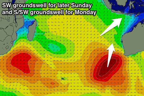 As touched on last update, a vigorous mid-latitude frontal progression is the source of this swell, with it already firing up south-east of Madagascar, generating a fetch of gale to severe-gale W/SW winds through our south-western swell window.
The progression will move east while weakening tomorrow, with a secondary re-intensification seen through our southern swell window, south-west of WA during the end of this week. With this we'll see a broad fetch of W/SW gales produced, tending more SW off the WA coast this weekend.
What will result is a large inconsistent SW groundswell, building Sunday afternoon and peaking Monday morning, with a secondary larger more consistent S/SW groundswell pulse for the afternoon, easing into Tuesday.
A slow increase to 4-6ft is due by dark on Sunday, with Monday morning seeing larger 6-8ft sets. A further kick is then due through the day to 8ft+, easing from a similar size Tuesday morning. A gradual drop is then expected through until Friday. More on this Thursday.
Weak E/SE trades tomorrow and Thursday are due to tend variable into Friday and remain so until Sunday, when they'll increase again slightly into next week.
16 day Bali Forecast Graph
16 day East Java Forecast Graph
16 day Sumbawa Forecast Graph
Ments: A mix of S/SW and S'ly swells are due over the coming days to 3-4ft+ or so and our poor gusty NW winds will continue until easing back to the moderate range Saturday, lighter into Sunday and Monday.
The surf will ease back Friday and become small, continuing Saturday.
Into Sunday and early next week though the pulses of SW and S/SW groundswell should fill in.
The first SW groundswell for Sunday should offer solid 5-6ft+ waves across exposed breaks into the afternoon, with the S/SW energy coming in Monday to 6ft+, easing off slowly Tuesday and further Wednesday and Thursday.
More variable winds are due from Tuesday, tending light SE through the end of the week.
16 day Mentawai forecast graph
16 day Nias forecast graph
16 day South Sumatra forecast graph