Stacks of south swell on the way for Southern NSW, best Friday morning
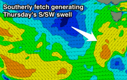
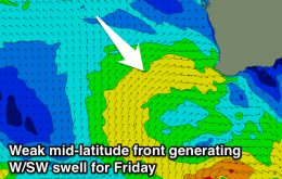
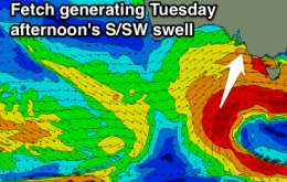
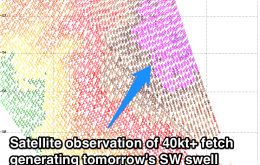
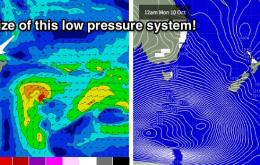
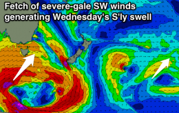
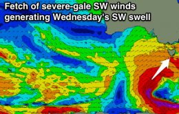
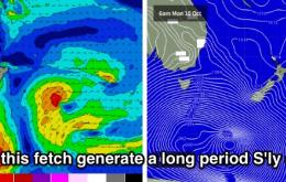
We’ve got a steady succession of south swells for the entire forecast period.
Strong new W/SW groundswell building tomorrow, dropping back a bit Wednesday, with some new S/SW swell for Thursday but with onshore winds. Cleaner and easing Friday.
Easing SW swell with a morning offshore tomorrow, smaller Wednesday morning ahead of an afternoon increase in new inconsistent SW swell. Onshore winds and easing surf Thursday, with an average W/SW swell for Friday.
W/SW swell for tomorrow morning with stronger S/SW swell for the afternoon down South, easing Wednesday with less than ideal winds. Smaller into Thursday and Friday with improving conditions. Average small weekend, better swells next week.
Mid-period W/SW swell for dawn tomorrow, with a stronger SW swell building through the morning. Not the best winds, likely W/NW-W around Torquay. Easing and cleaner Wednesday morning, then onshore Thursday. Small clean leftovers across magnets Friday morning. Average weekend.
Of much more interest to SE Qld surfers is a potential tropical system that’s popped up recently in the model runs, south of Fiji around Monday.
Sunday’s strengthening northerlies will be associated with a massive slow moving, multi-centered, gyre-scale Southern Ocean low pressure system.
Tiny Saturday, with a rapid increase in N/NE windswell Sunday afternoon, fading quickly Monday. New S'ly swell pulses from Wednesday.
Good new W/SW swell filling in tomorrow with early offshores, easing rapidly Sunday. New W/SW swell for Tuesday and better SW swell Wednesday morning with strong westerly winds.
Poor small and onshore tomorrow, larger mix of swells building Sunday with easing onshores, cleaner Monday morning and best in the South West Tuesday morning.