Exciting period ahead for surfers and weather watchers

South East Queensland and Northern New South Wales Surf Forecast by Ben Matson (issued Wednesday 7th January)
Best Days: Thurs/Fri: fun but easing trade swell, best conditions in SE Qld and Far Northern NSW (early mornings). Late Sun/Mon: strong renewal of E'ly swell with probably good (light) winds. Tues onwards: chance for a strong (rare) NE swell in SE Qld. Plenty of decent E'ly swell on the cards for the second half of next week too.
Recap: Building combo of short range E/SE and mid-range E’ly swells with gusty SE winds (Tues) throughout SE Qld, but winds remaining E’ly in Northern NSW (generally light to moderate south of about Yamba). Wave heights came a little under expectectations on Tuesday but seemed to reach forecast estimations today (at least in SE Qld). Certainly a good round of surf across the semi-exposed points of this region anyway.
This week (Jan 8 - 9)
The rest of the week should see a fairly even trend in the surf department. We’re close to the top of the swell cycle of this initial trade energy, and a gradual easing is expected from Thursday into Friday and the start of the weekend.
In similarity to the current energy, surf size will be biggest on the Sunny Coast's open beaches (between 3ft and very occasionally 5ft early Thursday) with slowly decreasing size with increasing southerly latitude (to perhaps 2-3ft+ across the Lower Mid North Coast).
The abating swell trend throughout this period won’t really be noticeable at open beaches from hour to hour, but with winds expected to be cross-onshore (if not straight onshore) at exposed spots, you’ll have to tuck into a smaller, sheltered location - and this is where the easing trend will be more pronounced (i.e. Thursday will be bigger than Friday, which will be bigger than Saturday etc). So, make the most of Thursday if sheltered points are your thing.
As for the local airstream, we’ll see a weakening pressure gradient so consequently slightly lighter winds in general, possibly variable (even briefly SW) for a few hours early mornings in some areas.
Otherwise, as per the last few days Thursday’s synoptic direction will remain out of the SE across southern Queensland, tending E’ly in Far Northern NSW and NE across the Mid North Coast.
On Friday we’ll see similar strengths in the northern regions but with a small counter-clockwise rotation as a trough approaches from Southern NSW. This will strengthen NE winds about the Mid North Coast during the day so expect difficult conditions away from protected northern corners (south of about Coffs).
However for the most part the semi-exposed points of SE Qld and Northern NSW should have small fun waves both days.
This weekend (Jan 10-11)
The swell cycle is expected to bottom out on Saturday, but there’ll still be plenty of surf about the coast.
Local conditions will probably be similar to Friday with light variable winds tending E/SE throughout SE Qld and Northern NSW, but with fresher NE winds about the Mid North Coast. Expect 3ft+ waves on the Sunshine Coast's open beaches grading to 2ft+ across the Mid North Coast.
On Sunday, we’re likely to see a renewal of mid-range E’ly trade swell from a retrograding depression south of Fiji later this week. Unfortunately, the models have cooled on the possibilities from this system since Monday's notes, but I still think we’ll see some great waves from it.
At this stage I’m not 100% on the timing - it looks like it’ll probably push through around lunchtime - so expect small residual swells through Sunday morning, similar to Saturday, and with generally light variable winds and sea breezes.
However once this new swell kicks in we should see some decent sets for the latter part of the day, pushing 3-5ft on the Sunshine Coast, 3-4ft on the Gold Coast and then incrementally smaller surf southwards. With some luck there won’t be much wind (model guidance is currently in support of this, due to a slack pressure gradient) so Sunday’s currently on target for some great afternoon waves.
Next week (Jan 12 onwards)
Last Monday’s notes detailed a couple of possible dynamic scenarios on the cards for next week.
Over the last two days, the model guidance has moved around a little and it seems we’re likely to see a mixed bag of both possibilities - the first being Sunday afternoon’s late afternoon push of E’ly swell (mentioned above) which should hold through Monday of a similar size, if not a shade bigger, with similar local winds in most regions.
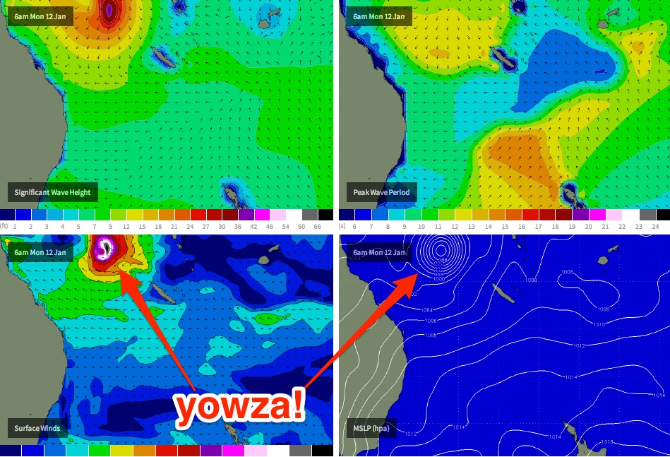
Otherwise, the TC developments in the Coral Sea this weekend look to be, to put it lightly, rather explosive.
However, southward tracking systems are not always great for swell production, unless there’s a slightly S/SW bias in the storm track, so for now the initial stages of this system are hard to be confident in (re: surf potential).
Additionally, there have been some major revisions of projected storm tracks/TC intensities with each recent successive model update, and I don’t think we’ll be able to lock anything in firmly for a few days yet. Nevertheless, all signs are still very positive for some dynamic surf next week.
Right now my main area of interest is for SE Qld and the possibility of a significant NE groundswell event. It’s worth pointing out that long period swells from this direction are extremely rare, which means that - due to a lack of previous swell templates to work off - the confidence levels are reduced.
At the present time most computer models seem to agree that by later this week or early in the weekend, we’ll have two systems (both possibly TCs) in the Northern Coral Sea - one near the Solomon Islands and the other embedded in a vigorous monsoon pattern crossing Cape York Peninsula.
It’s likely that we’ll see a southward trajectory from at least one of these systems over the following days but from there on, we've got a wide range of synoptic possibilities.
However some of the modelled characteristics of the Solomons system during its early stages is quite impressive - potentially 40-50kts of N/NE winds on its eastern flank, aimed somewhat within SE Qld’s NE swell window, with core wind speeds of 60kts+ (see chart below).
Whilst its way to early to start pinning down possibilities from here, early indications suggest a possible N/NE groundswell arriving around Tuesday or Wednesday (give or take), which will be sitting on top of an active, pre-existing E’ly swell (itself could still be worthy of 3-5ft at some exposed spots).
Obviously, many parts of the Northern NSW coast would be sheltered from a N/NE swell so we'll really need to see some satellite wind observations - once the cyclone(s) form - before starting to estimate its surf potential south of Byron Bay.
Beyond Tues/Wed there is reasonable confidence that we’ll see further activity in our swell window that’d provide strong E’ly swell through the second half of the week. But there’s not much use in debating specifics until we get closer to the evolution of these cyclones.
So for now, it’s worth penciling in much of next week for some flexi time - and (local winds pending) if we do end up seeing a reasonable NE groundswell, it’ll be worth considering sniffing out some of those coastlines that rarely experience swells from this direction. More on this in Friday’s update.
Comments
any report for southern NSW over the next week???.....OK where is the projected report for Sydney and south coast NSW. Gold coast today is getting the swell early they know that. Where is our report?? There are a lot surfers in NSW who have been having long periods of shit and flat surf that we need HOPE so how about it!!!!!!!!!!!! I am guessing we will get a bit of size by Sunday with a downward spiral on Monday with lighter N winds??? Correct or not???
Ah bugger. I uploaded this forecast to the Sydney region (the Sydney notes were uploaded around 5pm.. they are here: https://www.swellnet.com/reports/forecaster-notes/sydney-hunter-illawarra/2015/01/07/plenty-swell-plenty-wind).
All fixed now, sorry for the confusion.
I love you mate hahahahahah!
Re: "YOWZA". Which model is shown in this picture? The WAMS animation on SwellNet does not play out like this. Which model is SwellNet Showing? And which model is being used to disturb our sleep with perfectly concentric isobars?
I look at the kiwi met site, Metvuw and they (sorta) show a third scenario. It would be good to know a bit more about the competing models Ben - when you get a moment...
Cheers, Rrobb
It's GFS - which is the same model used by Metvuw. Not sure which model run it was from yesterday but probably 18Z.
However each run across every GCM model has been moving around a lot over the last few days (and will continue to do so for the short term) so wide variations are certainly possible.
I don't have time to run through an individual model assessment right now but will try to do that in the coming days.
GFS has changed its tune somewhat this morning. All WAMS use the GFS weather model as input, including SNs.
Thanks,
I appreciate your replies. Of course, I surf. But I came here (to Australia) in 1995 while circumnavigating in Orinoco Flo, a carbon-wingmasted catamaran I built. I’ve been a weather enthusiast since my fishing childhood. I placed my comment as I am pretty ignorant about the different computer models, and where they are accessed etc, and thought perhaps some of your other subscribers might be equally curious, as Ben's gauge of forecast reliability is often how well the different models agree. Of course it is possible that Ben may have made such information available in earlier Forecaster notes which I have only recently been checking. (With great interest.)
Oddly, your WAMS forecast (what I took to be) a cyclone some weeks ago that was to run down the coast pumping swell about the time of this current potential cyclone, but it faded from the charts after a day. Knowing cyclones and their general flakiness I thought a forecast so far ahead of time was in with a poor chance of being realized in its particulars.
Rrobb
Yeah the models often have TCs popping up the long term projections at this time of the year, but there is a pretty reasonable level of confidence that we'll see *something* develop in the Coral Sea this time 'round due to the association with the passing MJO phase.
Hi Ben, how are the winds on GC/NNSW Monday? (assume light early possible SW tending SE?)
Just want to confirm before angling for a day off.
Thank you!
Too far out right now to have confidence enough to take a day off! Seriously, things are changing a lot with each model run and you're best off checking back tomorrow.
OK will do
The MJO is the mothership!
The MJO is the Fathership ,
It wants to shove its influence in anywhere it can . The Mother ship is the lower sth ( higher ) lattitudes supporting features that allow or give into the MJO's persistance . If there is no supporting features then the MJO ( father ) gets sent packing into the Mid Pacific . Pretty stereo typical Oceanic family ...
Rrobb ,
The models will throw out all sorts of scenarios , use you chart memory and general noust to decify what is the most likely outcomes . There are patterns to the supporting features which are governed by local SST's and also other regional influences .
Unfortunately if you don't have long term experience of watching certain patterns ( ie have LK ) then sometimes your just at the whim of models ... and we all know how flippant and selfish they can be ;-) .... Treat them like charts , the more radical or dramatic the changes are on each run the less reliable they will be in a given scenario ...
That being said when the above mentioned Mother and Father get into a blue , everyone ends up confused . At the end of the day Mother has her say ......
Looks like it's strongest right now/coming day or two, most forecasts have it moving off to the east while weakening into next week.
I'm away from the puter but can someone pull up the charts for twin cyclones Ann and Agi from first week January 1988?
Just to see if there is any worthwhile analogue.
That's from the BOM @ http://www.bom.gov.au/cyclone/history/agi.shtml
Love those words explosive - time for a road trip
That's Agi what about Ann?
And Anne.. http://www.australiasevereweather.com/tropical_cyclones/1987_1988/jtwc/tropical_cyclone_anne.htm
Cat 5 before crossing New Cal and then weak Cat 1 after that.
Nice work Mick/Craig cheers;)
Wish I had the charts to see what synoptic setup Anne was moving into. Remember Steve?
Only vaguely Craig but I remember Wayne Deane surfing 8-10ft Big Groyne Kirra during the swell from that twin cyclone event.
Ill try and track down the archive charts when I get home.
Some interesting reading here, FR
http://www.webcitation.org/6G2pXL0qA
Hey Ben, Sheepy and other weather guru's, I remember it was probably two years ago since the sniff of one of these NW swell events failed to materialise, But what i don't remember about that scenario as a farmers perspective this one feels a little more hopeful. There have been these big rain squall storms typical if you like of a weather 'event'. I'm sure much chart watch is happening but also 'local' weather to me is a signpost, in your years on the coast Sheepy has the appearance of these big cumulonimbus storm showers ever preceded a big NE swell event. As it was taught to me, it was a sign the monsoon was imminent, and it doesn't surprise me then that the weather models are all going nuts. You can feel it in the air. And Donny what's it going to take to move that sand in that secret spot of yours, this trade swell is doing nothing but breed a thousand kooks is it not?
This is a good string with a lot of "lore" coming out of it and I apreciate the comments. Particularly Southey and dromodreamer05 pointing out that human memory of local events echoing off more distant weather can be an indication. When you consider the chaos theory's joke about the butterfly in the Amazon, you see the impossibility of a computer model ever - EVER - being 100%. Unless of course God (or Ben) give it a nudge!
I was surfing Cactus in 1972(?) and we had an odd offshore wind with rain. It didn't rain so much then and was memorable. Later I got the weather map and found that a front ran diagonally more or less to Broome, where a Cyclone was in play. "Local" weather? No such thing! It's all global and, as dromodreamer05 notes, "local" may be indicative of distant events.
There is one negative.... Donny's W.A low moving into central Australia and upsetting the high pressure belt, which is critical for a serious cradle... But a lot can happen between now and then.... Let's hope the inland low disintegrates....
Yep....no cradle and no surf from anything out to the east. My tropical low looks to seriously drench the inland Aus!!!
That was my ' convoluted ' point SD .
Not only has SA advected a lot of the Monsoons
Moisture down into the SE . ( the father ' MJO ' ,
Has blown it's load ) whats left over will not be
Supported by a higher lattitude ridge / high .
The upper high which is likely going to cause a
retro grade of this system Monday May help a ridge
replace it in the eastern Tasman , but it will also 'vent '
To much vertical higher atmosphere what's
left of that monsoon flow .
So something will spin up , it will only feed on local waters
as the MJO had already peaked ' prematurely ' .
Agi & more so Anne also had uppers that barreled her SW ,
Most likely achieving a captured fetch , especially on a pre agitated
Sea state .
That being said if it lasts long enough and dances around like a peacock
In heat , some " motherly " support feature " ie ridge with aligned uppers might
Make something happen later this month. .
Donny... Still waiting on that NT/WA border cyclone...... ;) ..... The old 163e - 12s circle is looking pretty good.... And the minge that drifted across the cape might throw a curve ball too lol
Southey, Odds are on that something swell wise should eventuate from that solomons low... Can't see it being "all time".... But for every negative there is a positive... If current predictions are close, down my way could be in store for a rare event - a se swell!!!!!!! .... And a certain very VERY rare right in NZ that only breaks during north swells may come to life.....
Yeah I missed it by that much SD. If only she moved a few kms to the west then she'd be game on!!!
Some serious wind and rain though no cyclone thanks to the lovely land mass we call Oz.
SE swell. Geez the Cobra could be on. Message me where this very rare right is Sheepy you don't mean slab north of Keri Keri do you?
No, Mick..... A good way se of there..... If something like this occurs, and the north swell can get in -
Expect this to happen...
Message you shortly.... ;)
"And a certain very VERY rare right in NZ that only breaks during north swells may come to life....."
'Pa' point haha..
Geez there are many Sheepio, many;)
surfed the pa thats so rare and the McLeans reef on the otherside !!
Aint pa point welly.... Keep guessing ;)
Arguably the best right in New Zealand....