Plenty of swell, plenty of wind

Sydney, Hunter and Illawarra Surf Forecast by Ben Matson (issued Wednesday 7th January)
Best Days: Entire period: plenty of E/NE and NE swell (biggest from Friday onwards), although fresh NE winds will cause problems at open beaches. Mid-late next week: chance for a solid NE and S'ly swell.
Recap: Very small surf for the last few days, with light winds for much of Tuesday and early Wednesday, and freshening NE sea breezes this afternoon. Seems to be some small signs of building trade swell across the coast although it’s behind schedule and under size expectations so far (of which the North Coast/SE Qld coast experienced similarly undersized swells from the same source yesterday and today).
This week (Jan 8- 9)
Based on today’s (under) performance I’m going to pull back Thursday’s expected size from the distant trade swell source, to an inconsistent 2ft at open beaches.
Wave heights are slowly increasing across SE Qld and Northern NSW but I’d rather be a little more cautious on tomorrow's numbers as the local NE airstream (initially expected to kick up some short range energy tomorrow) has also been slightly wound back in its timeline.
Exposed swell magnets may see a few bigger sets if we’re lucky but conversely, south facing beaches (i.e. Bondi, Cronulla) will remain very small. Freshening NE winds will render most beaches bumpy during the day but they should be lighter early morning.
On Thursday afternoon/evening we’ll see the nor’easters strengthen a little more in our near swell window so Friday should see bigger waves in the 2-3ft+ range at north-east facing beaches. Again, we’re looking at gusty NE winds for much of the day so keep a lid on quality expectations. And south facing beaches will be considerably smaller.
This weekend (Jan 10-11)
No major changes to the weekend forecast apart from a slight downgrade in size from both sources - a persistent E/NE trade swell and some local short range NE windswell.
The former should motor along in the 2ft+ range, whilst the latter is likely to provide 2-3ft+ waves however this will only be at beaches that are open to the north-east (south facing beaches will remain much smaller).
No major change is expected in the local wind field either - mainly fresh NE - but at this stage it’s too early to identify any possible small windows of lighter periods. I’ll give this a whirl in Friday’s notes.
Also, as detailed in the notes for next week (below) we may see a late push in larger E/NE groundswell on Sunday afternoon but the models have been moving around so I’m not totally confident in this right now. But it’s definitely worth flagging for now.
Next week (Jan 12 onwards)
Monday’s notes detailed a couple of possible dynamic scenarios on the cards for next week.
Over the last two days, the model guidance has moved around a little and it seems we’re likely to see a mixed bag of both possibilities - there’s much more confidence for a Tropical Cyclone (or two) to form in the Coral Sea and track southwards - into our swell window - but we’ll also see a reasonable easterly push from a retrograding depression south of Fiji, arriving either late Sunday or (more likely) early Monday morning.
Right now this first E/NE swell has been downgraded since Monday’s notes and will probably top out at around 3-4ft. Local NE winds are expected to maintain strength through the start of next week and we should see short range NE swell holding at least 2-3ft+ through this period. A southerly change is on the cards for late Tuesday or Wednesday. Stay tuned for more on that over the coming days.
Otherwise, the TC developments in the Coral Sea this weekend look to be, to put it lightly, rather explosive. However, southward tracking systems are not always great for swell production, unless there’s a slightly S/SW bias in the storm track, so for now the initial stages of this system are hard to be confident in (re: surf potential).
However, most of the models push this developing system into a good part of our NE swell window early next week (just south of New Caledonia - see chart below), setting up a decent chance for a solid NE groundswell through the middle to latter part of next week.
It’s been quite some time since we saw a quality groundswell from this neck of the woods (last one I can think of offhand was mid-March last year) and such swell events are often very strong, long lasting and - local winds pending - capable of delivering some of the best waves southern NSW has to offer.
And just to add further excitement into the picture, the computer models are also suggesting a cut off low in the Bight could migrate eastwards into the southern Tasman Sea around the same time, offering a similarly strong round of large south swell at the same time.
So, whilst it’s still too early to book in some flexi-time, we’ve got some fantastic East Coast potential lining up for the second half of next week. More on this in Friday’s update.
Comments
Bit confused why would it be great with a NE swell and Sth swell pushing against each other at the same time I would prefer one after the other.
Depends on where you wanna surf. But many beachbreaks love these swell combos.
If the tropical cyclone enters our swell window, how far down the south coast will the swell reach?
There's no hard and fast rule. But just having a TC in the water doesn't guarantee swell. It's all about the supporting synoptic features.
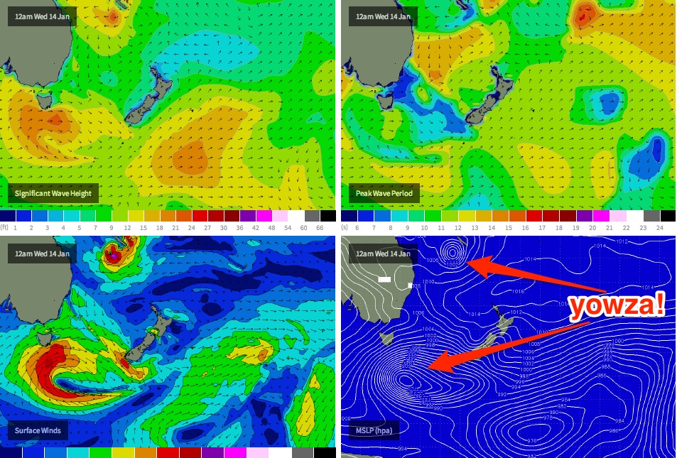
Ben, I hope it intensifies and heads direct south. goes as far as say off the Coast of Taree 100 miles hahahhah. that would be great. dreaming again. Oh I get so excited when I see all the YOWZA markings on the maps :)
Evo, Heres a theory....!
A wave, such as a water wave, consists of a series of crests and troughs. When waves collide, if those crests and troughs happen to correspond, they reinforce each other, yielding a larger wave. That is called constructive interference. In that case the waves are said to be "in phase".
At the other extreme, when the waves meet, the crests of one wave might coincide with the troughs of the other. In that case the waves cancel each other and are said to be "out of phase".
That situation is called destructive interference.
I seen this last week down at Palmy a NE/E swell of 1.2m and a SSE swell of 1.8m best waves I've seen on that beach for a long time, peaks everywhere and no wind;)
I believe on beachies two opposing swells work awesome.
I agree Wellymon, it sometimes creates great peaks and not those long close out walls.
Well I am down the south Coast from Monday onwards but surfing the protected areas of Kiama over the weekend. Isurf a place if the swell gets to 5 or 6ft or bigger on Sunday it will be down the line left walls. shhh Secret. Have a good swell guys.
Went for a grovel yesterday in the epic 1' conditions. As I headed out, chatting to a bloke, he said "3.9 metre swell due next Monday". My first thoughts were sceptical, to say the least.
Not sure where he gets his info from but it sure ain't weather charts.
It does look rather good for the ne swell though, by Wednesday and later.
And a double cyclone/tropical low possibility. Can't say I've seen that too often, but at this point the second one may produce not much for NSW, but my contacts in Qld will be happy.
As for wellymon's constructive and destructive interference, the coastal effects tends to mean the swell direction is turned more easterly as it gets closer to the coast, whether it is from the north or south, so if there are two swells in the water from different directions it will tend to cross each other, and as kerry says this can create great peaks up and down the beach spreading the crowds and making everywhere good regardless of the shitty banks.
Will be nice to be in the water with some energy out there. Must be a million places that will potentially light up on this. I may just be in the neighbourhood of a few that will have very few surfers on them.
Think I may just gorge myself on this swell. Last week before going back to work.
with the NE winds as they are..it's all about whether the south facing beaches start to get some action
The way each run is swinging about, I have a horrible feeling of impending disappointment about all this.
There, that should fix it. :-)
Compare the synoptic chart in the report above, to the latest ACCESS and GFS model runs (EC is also on board but with more focus on the Southern Ocean low than the Coral Sea TC).
I hear what you guys are saying about beach breaks but with so called two major swell events on the cards I was hoping no beachies (too big) only point and reef breaks which im sure would be better with one direction major swell at a time. Looks as if its all a hoax now anyway.
Just give me a 5ft ne ground swell with light winds on the new Cenny coast and ill be satisfied