Several fun swells on the way

South East Queensland and Northern New South Wales Surf Forecast by Ben Matson (issued Monday 15th December)
Best Days: Early Wed: Fun but easing, inconsistent E'ly swell, with S'ly winds developing across Northern NSW (NW winds ahead of it, including SE Qld). Late Thurs/early Fri: another slightly stronger E'ly swell, best across the Mid North Coast, with NE winds late Thurs tending fresh S'ly during Fri again (early period of NW winds in Far Northern NSW and SE Qld, but surf will be smaller here).
Recap: Local crowds not withstanding, the weekend delivered some unreal waves right across the region. Plenty of strong lines across semi-exposed points, and sizeable bombs at exposed beaches, especially in Northern NSW. Wave heights have slowly trended down from Sunday and winds are a little lighter today, with pockets of W/SW winds early this morning.
Next week (Dec 16th - 19th)
Plenty of swell for the rest of the week - you’ll just have to work around the winds. Today’s swell will continue to ease slowly into Tuesday, and winds will eventually swing to the NE and freshen - sooner and stronger across the Mid North Coast compared to the Far North NSW and SE Qld coasts - so aim for an early session for the best conditions, and biggest waves (don’t expect much size on the points either - it’ll be best suited to the beachbreaks).
Late afternoon, we’ll see a small new pulse of long range E/SE swell that should provide some bigger waves in the few hours before dusk, possibly up around 3ft at exposed spots - however it may not really be that distinguishable from the existing mid-range energy, and will be inconsistent too. And with fresh NE winds on it by this time conditions won’t be great either.
Wednesday morning looks like a better time to capitalise on this new swell. A gusty southerly change will be working its way up the coast - into the Mid North Coast by mid-morning, then the Far North Coast through the afternoon.
Ahead of it, winds should be moderate westerly in Northern NSW and NW through SE Qld, so the beach breaks should offer fun clean waves. South facing beaches in Northern NSW will pick up a small low quality windswell in the wake of the change, but Wednesday will be mainly all about the distant E/SE swell for the early session before the wind change. Some exposed spots in Northern NSW may see occasional 3ft+ sets but for the most part we’re looking at peaky 2-3ft waves at most open stretches.
Wednesday’s southerly change is expected to reach the Qld border around dinner time but won’t have much strength and will probably peter out by the early hours of the morning, leaving Thursday morning with mainly light variable winds across most areas ahead of a freshening nor’easter after lunch. A small mix of residual swells should maintain inconsistent, pulsey 2-3ft waves at most open beaches in Northern NSW, with slightly smaller surf across SE Qld beaches.
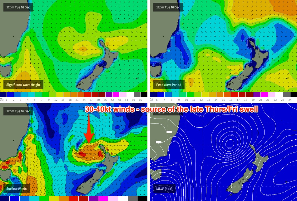
Late afternoon will herald the arrival of yet another pulse of E/SE swell from the fetch off New Zealand’s North Island. In fact, it’s expected to become briefly super-charged on Tuesday afternoon as a weak tropical low - that formed off the Central Qld coast over the weekend (but is not actually a swell producing system) - travels SE through the trough line across the Northern Tasman Sea, and merges with the primary fetch.
This is modelled to spin up a fresh E’ly fetch aimed a little further south than the current system, with wind speeds in the 30-40kt range (see image below). This means that locations to the south will probably fare better than those to the north in the size department, especially north of Byron (in short: expect smaller waves in SE Qld from this pulse).
An arrival is pegged for the region very late in the day (probably after 4pm) and sets should approach 3-4ft+ right on dusk at times across the Mid North Coast, with perhaps some late 3ft sets across Far Northern NSW and SE Qld if we're lucky. Our surf model isn’t picking this up very well right now but should correct itself over the coming days.
My main concerns with this swell relate to (1) Thursday late afternoon’s nor’easters, which could reach 15-20kts at the same time the swell arrives (thanks to an advancing southerly change on the Far South Coast), and (2) an expected peak in size overnight, that may offer only a brief window of good waves early Friday morning as surf size begins to throttle down. In fact, this particular swell is expected to ease a little more rapidly than the Tues/Wed swell, due to the shifting fetch alignment (from east to north-east) as it develops. So it could be down by a foot or so by late morning with possibly even smaller waves by late afternoon.
In similarity to Wednesday morning, we’re looking at an advancing southerly change on Friday, beginning across the Mid North Coast in the morning and reaching the Far North Coast through the afternoon, with NW winds ahead of it. And, south facing beaches in Northern NSW should pick up a low quality southerly windswell during the afternoon.
Therefore, the beach breaks will be your best for an early paddle but let’s fine tune the arrival of the southerly change in Wednesday’s notes. Otherwise, southern corners will offer protection in the lee of the change.
This weekend (Dec 20th - 21st)
Nothing of major interest this weekend - looks like we’ll mainly see a mix of small leftover S’ly swell from Friday’s pulse, and some minor background E’ly energy - just a couple of feet max at open beaches. Hopefully Wednesday will see some changes in the models towards a more active period! But right now it looks like swell magnets only.
Long term (Dec 22nd onwards)
Broad trades developing north and north-east of New Zealand from this weekend signal a return to small but long-lasting distant E’ly swell for the foreseeable future (beginning early-mid next week, that is).
One other region that's also going to be on my monitor for the longer term is the Northern Tasman Sea, which is showing signs of troughiness throughout the longer term models runs. This could very well be the source of a better quality NE swell mid-late next week for southern NSW. Check back in on Wednesday for more details.
Comments
Hmmm. Latest 00Z GFS run has some interesting suggestions right off SE Qld's doorstep this weekend (that wasn't apparent in earlier model runs). Broadly hinted at by other models too.
"Local crowds not withstanding, the weekend delivered some unreal waves right across the region. Plenty of strong lines across semi-exposed points, and sizeable bombs at exposed beaches, especially in Northern NSW. Wave heights have slowly trended down from Sunday and winds are a little lighter today, with pockets of W/SW winds early this morning."
That it did.
So why did your North Coast report give ratings of less than five- 2,3 and 4 if memory serves correctly- for the whole weekend?
It makes no sense for your forecasting and recaps to be correct but your reports to be completely at odds with that.
btw SD, you ready to throw a dart at the dartboard re: waves on Xmas day?
2-3ft tradewind swell with light morning land breezes and afternoon nor-easters is my call.
Actually the ratings were 3, 5 and 7. But I have just checked the Ballina reports, and agree - they weren't especially useful this past weekend. I'll have a word and make sure it doesn't happen again.
I was referring to Fri/Sat/Sun: 2,3,5.
Anyhow, up to you how you QC your reports but it's weird when you nail the forecast and the reporter can't figure out that over the headland the waves are clean and pumping.
3-4ft and clean at the top end of the goldy this morning. More so 3ft with the very odd freak 4ft set. Swell died in the arse after about 7am but.
Gee. I go and do the xmas shopping and the banter dries right up.......... ;)
FR.... Yeah I second that call... I watch that tropical minge near New cal around the time of your call with interest. I also not some interesting developments far out in the pacific.... Duke of Ed' islands and east coast Fiji would be the go....
The low has ramped up..... strong gale...
Nice sat pick-up.
Pretty close to spot on with current forecasts. Perhaps a smidgen further north, but only by a bees d!ck. For me this fetch is still pointed to locations further south than SE Qld/Nth NSW.
Might up my Xmas call by a foot or so. 3ft+ with the odd bigger one.
That trade fetch is looking better positioned and stronger now.
Doggy, if you only saw what I've seen the last few days. Warm water, punchy lefts, low crowds.
Damm.
Lefts? Really? from a S/SE swell?
I saw your jelly fish to Steve. Fecking plagues of them!!! Anyone know what they're a sign of?
I've seen garage sales on the weekend..... Xmas crowds in Hobart..... A few busloads of tourists at the bakery..... :/
Thunderstorms were a novelty down here yesterday....
probably a little more E in the swell than that Don. Anything from the North Island or above always has plenty of E in it.
Whats your Xmas Day call Donny?
Catostylus are a sign of oceanic/global warming, and possibly ocean acidification.
Been called by marine scientists for a few years that jellyfish numbers would increase as calcification becomes more problematic.
Hmmmm. light variable winds early, tending NE strengthening to 15ish K..... Chance of heavy rain in NNSW and thunderstorms in Qld..... Long distance meandering 2 to 3 foot easterly swell..... Chance of "morning sickness" re' ocean surface...... Still worth watching that "dip" near New Cal........ Still very "troughy" inland......
Surfed the point numerous times in the 70s and 80s when there were plagues of these big blue jelly fish so to say its global warming is a big call,imo this year has been very similar season wise to what i would call normal or comparable to 70s -80s.
That last swell was very underwhelming on the sunny coast. Weak.bad winds.there was a two hour pulse on the points sat late arvo.gone by sun morn.